upper waypoint

From PurpleAir to AirNow, Your Air Quality Maps for Wildfire Smoke

Save ArticleSave Article
Failed to save article

Please try again

Bay Area residents have become used to the ritual of checking online maps for local air quality amid burning forests and chaparral near and far.

During the 2018 Camp Fire, AirNow, an air quality website maintained by a partnership of states, the federal government, Canada and Mexico, crashed because it could not handle so many people flocking online to put numbers to what their noses were telling them: The air seemed really bad.

The failure sent web users rushing to alternative, unofficial websites like the interactive, crowdsourced map maintained by PurpleAir, a manufacturer of low-cost air monitors.

But users have noticed a discrepancy between what official sites are reporting and the readings displayed on PurpleAir.

So, what’s the deal?

Broadly put, PurpleAir provides more localized, more current and less accurate readings than AirNow.

The EPA and the U.S. Forest Service have a project of what some may consider to be the Holy Grail of air quality maps: combined readings taken from PurpleAir’s low-cost sensors and those from official government monitoring devices, all in a single map. Click here or on the image below to access the map; the circles represent official government monitors, the squares indicate PurpleAir sensors, and the triangles show temporary monitors set up by government agencies.

Screenshot from AirNow Fire and Smoke map, a pilot project, on Sept. 4, 2020.

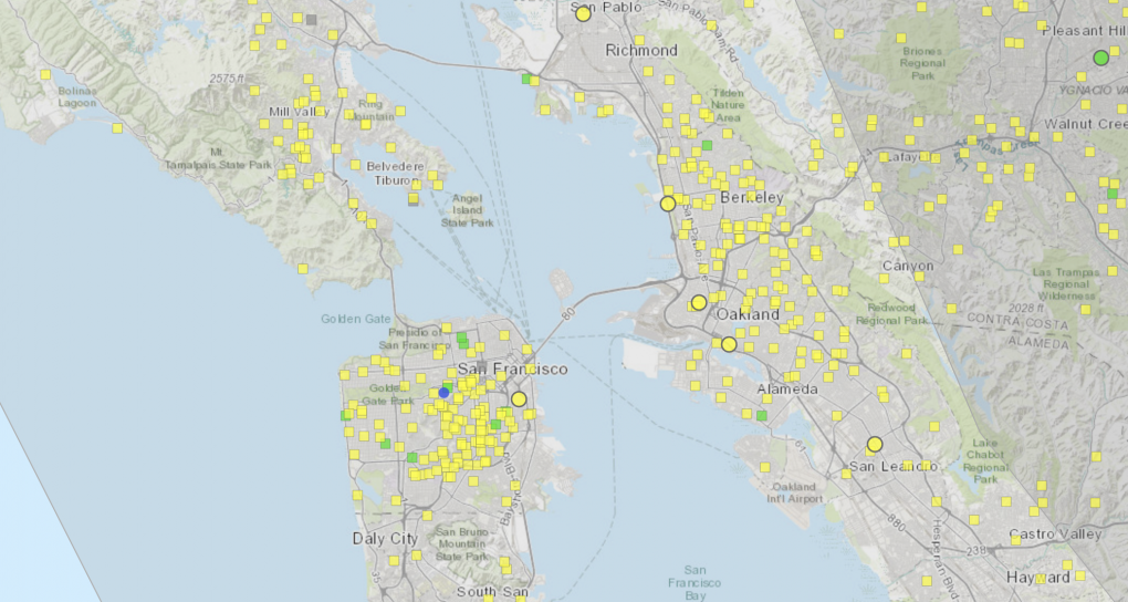
“While these [unofficial] sensors don’t meet the rigorous standards required for regulatory monitors, they can help you get a picture of air quality nearest you, especially when wildfire smoke is in your area,” the website states.

PurpleAir readings and those from government sensors like the ones maintained by the Bay Area Air Quality Management District differ in several key ways: speed, accuracy and placement.

Users of PurpleAir can toggle between real-time data and readings averaged over the last 10 or 30 minutes. The data comes from the commercial sensors the company sells, which members of the public install on porches, yards and other neighborhood sites. The readings can be helpful for people deciding whether to go for a walk or engage in other outdoor activity. (Remember to deselect “indoor sensors” to see outdoors-only readings.)

The AirNow site displays hourly, not real-time, readings. The government sensors that send data to AirNow are very expensive, state-regulated and regularly calibrated by scientists to accurately measure the density of wildfire ash and other particles in the air. But they are more sparsely located than PurpleAir’s network of hundreds of monitors in the region. In contrast, PurpleAir’s devices rely on a laser to count the particles in the air, and use an average density to determine air quality at the monitor’s location. The calculation is an estimate, however, especially during fire season, as woodsmoke particles have a different density from gravel dust or other pollutants.

“To try to remedy the situation, we’ve had a whole bunch of different groups, different scientists, different universities, different agencies look at the data and convert it into a calibrated reading that more accurately compares to the EPA’s data,” PurpleAir founder Adrian Dybwad said.

PurpleAir users can now toggle among several conversions — one listed as “US EPA” developed by the U.S. government; “LRAPA,” developed by the Lane Regional Air Pollution Agency in Oregon; “AQandU,” developed by the University of Utah; and another labeled “WOODSMOKE,” developed by researchers in Australia. These readings will align more closely with those from official sites.

An earlier version of this story was published on Sept. 4, 2020. Jon Brooks contributed.

Sponsored

lower waypoint
next waypoint
Homeowners Insurance Market Stretched Even Thinner as 2 More Companies Leave CaliforniaSame-Sex Couples Face Higher Climate Change Risks, New UCLA Study ShowsWatch Ferns Get FreakyAs California Seeks to Legalize Psychedelics for Therapy, Oregon Provides Key LessonsHoping for a 2024 'Super Bloom'? Where to See Wildflowers in the Bay AreaCalifornia’s Commercial Salmon Season Is Closed Again This YearInsurance In California Is Changing. Here's How It May Affect YouThese Face Mites Really Grow on YouEverything You Never Wanted to Know About Snail SexWhere to See Cherry Blossoms in the Bay Area This Spring