upper waypoint

A Break in the Weather for Big Sur Firefighters

Save ArticleSave Article
Failed to save article

Please try again

The Soberanes Fire burns near the Big Sur coast. The fire burned 43,400 acres and was 18 percent contained as of 7 a.m. on Aug. 2, 2016. (Cal Fire via Twitter)

Update, 11 a.m. Thursday, Aug. 4: The massive Soberanes Fire burning near Big Sur grew by more than 4,000 acres overnight and has now burned about 51,000 acres, or nearly 80 square miles, according to Cal Fire. The fire is 27 percent contained.

Damage reports remain unchanged, with 57 homes and 11 outbuildings destroyed. Another 2,000 are under threat.

Fire investigators have determined the blaze was started by an illegal, abandoned campfire.

Update, 2 p.m. Wednesday, Aug. 3: The incident command on the Soberanes Fire, burning in the mountains along the Big Sur coast south of Carmel, said early Wednesday the blaze has consumed 45,800 acres -- 72 square miles, or nearly equivalent to the area of Oakland.

Sponsored

Weather forecasters say the 5,500 people now assigned to corral the Sobranes blaze are about to get a break, with a deepening layer of moist marine air and lower temperatures replacing the hot, sunny conditions that have aided the fire's spread along ridge tops and river bottoms. The fire is just 25 percent contained.

A wind shift combined with a fire burning in the Sierra foothills northeast of Fresno has triggered an air quality alert from Bakersfield to the Delta -- the entire San Joaquin Valley.

Damage reports remain unchanged, with 57 homes and 11 outbuildings destroyed. Another 2,000 residences in an area stretching from Carmel Valley down to Tassajara Hot Springs on the fire's eastern flank remain under threat.

One person has been killed fighting the fire. Robert Reagan III, a bulldozer operator, died when his machine overturned during the first week of the blaze.

Authorities announced Tuesday they had determined an illegal campfire in a remote part of Garrapata State Park sparked the fire on July 22. Monterey County District Attorney Dean Flippo said those responsible for the fire could face criminal charges:

From the Monterey Herald:

“We have a death that occurred — the bulldozer driver — we have structural damage and all of that will have to be sorted out,” Flippo said. “You’re looking at negligence as opposed to intentional, but it’s criminal liability. ...”

... Cal Fire officials are urging anyone who might have been in the area the day of and the days leading up to the start of the fire to contact the agency at 1-800-468-4408.

“Due to the cause of this fire, we’re appealing to the community for any additional information,” Cal Fire spokesman Jonathan Cox said. “We appeal to anyone to please come forward and give any information they have, no matter how inconsequential they think it is.”

Update, 5:30 p.m. Tuesday, Aug. 2:

The Soberanes Fire burning along the northern Big Sur coast was caused by an abandoned campfire, according to a tweet from Cal Fire.

According to the Associated Press:

Fire information officer Deborah McClain said Tuesday that investigators determined the blaze started July 22 in an area of Garrapata State Park where campfires are prohibited.

McClain says officials are still trying to determine who started the campfire and are asking for information from campers who were in the area before the massive blaze charred 67 square miles and destroyed 57 homes.

A bulldozer operator working the fire lines was killed last week in a rollover accident in steep, forested ridges.

Update, 11 a.m. Tuesday, Aug. 2: The Soberanes Fire has burned 43,400 acres, or nearly 68 square miles, and remains 18 percent contained, according to Cal Fire.

The fire has destroyed 57 homes and 11 outbuildings. An additional three structures and two outbuildings were damaged.

About 2,000 structures are threatened, according to Cal Fire.

Meteorologists say the weather is not expected to aid the more than 5,400 fire personnel battling the blaze. For the next few days temperatures in the fire area, along the northern Big Sur coast, are expected to stay in the mid-to-high 90s, with cool coastal air failing to reach the fire during the night.

"You know it's typical summer-type weather with steep temperature contrasts from inland areas to the coast," National Weather Service meteorologist Rick Canepa said. "Really, we don't see too much change actually through the week and probably pretty much through the month."

/photo/1
Update, 9 a.m. Monday, Aug. 1: The Soberanes Fire continues to chew through rugged, drought-stressed terrain along the northern Big Sur coast, exacting a rising toll in property damage.

Fire managers said that as of Monday morning, the fire has burned nearly 41,000 acres -- about 63.4 square miles, an area about three-quarters the size of Oakland. The blaze is 18 percent contained and has destroyed 57 homes and 11 outbuildings since it began in Garrapata State Park on July 22.

The blaze threatens as many as 2,000 more homes, Cal Fire says. Several hundred people in the area -- inland and southeast of the town of Carmel, have been forced to leave their residences as the fire has spread.


An extraordinarily large force of fire personnel -- nearly 5,300 people -- has been deployed to contain the blaze. Fire managers said last week that full containment could take until Aug. 31; they added over the weekend that in the worst case, the blaze could grow more than fourfold from its current area and reach 170,000 acres.

If that scenario comes to pass, the Soberanes would join two other Big Sur fires as among the largest in modern California history. The Marble Cone Fire, a lightning-sparked blaze, torched 177,866 drought-desiccated acres in 1977. The Basin Complex Fire burned 162,818 acres in 2008.

On its southern flank, the Soberanes Fire has burned into the footprint left by the Basin conflagration. Fire managers have commented that the fuels in the area, including fallen logs and dead or dying standing trees called snags, are heavier than expected for an area that burned so recently.

Among those concerned about the fire's impact are grape growers and winemakers. According to KION, the local CBS outlet in Salinas:

Monterey County's wine industry is worth more than $100 million. Even though Carmel Valley only produces one percent of the county's wine, the fire could shake things up.

The Soberanes Fire is burning seven to eight miles away from the nearest vineyard in Carmel Valley, but it carries a more immediate threat.

"We have to worry about something called smoke taint, which is when ash and smoke affects the skins of the grapes. And then if it affects the skins of the grapes, it can affect the wine," said Kim Stemler, executive director of Monterey County Vintners and Growers Association.

It's unclear if it will happen but if it does, there are ways in the production line where it can be treated.

"Most of the grapes in Carmel Valley have not gone through veraison," Stemler said. "Veraison is where the grapes change colors. After veraison, they're really susceptible to smoke taint, so since it's still really early, it's a good sign."
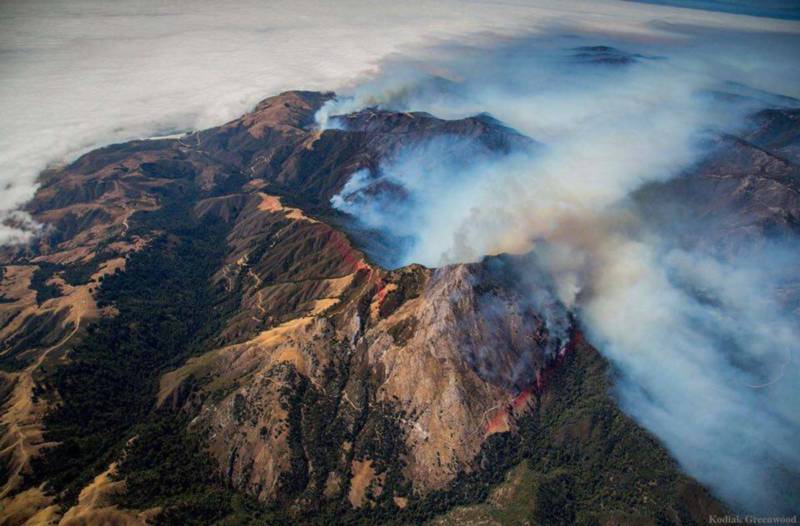
Original post (Friday, July 29): A virtual army of firefighters -- nearly 4,300 people -- has entered the second week of its battle to contain a major wildfire spreading through the mountains just inland of the northern Big Sur coast.

Cal Fire says that the Soberanes Fire, which started in Garrapata State Park last Friday morning, has burned 31,386 acres. That's 49 square miles, roughly the same area as San Francisco. The blaze is just 15 percent contained, with full containment forecast to take another month.

Smoke from the fire continues to prompt Spare the Air alerts in the Bay Area and is contributing to poor air quality throughout the San Joaquin Valley.

Officials say that the fire has burned 41 homes so far and threatens as many as 2,000 others. About 350 residents of the sparsely populated area have been forced from their homes.

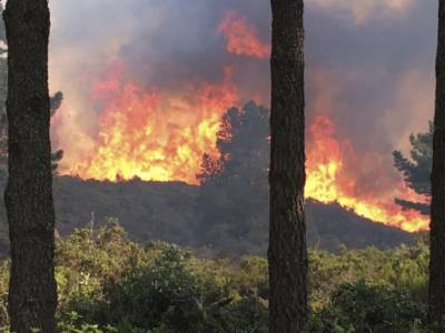
A wall of fire advances up a ridge east of Monterey County's Big Sur coast on Thursday.
A wall of fire advances up a ridge east of Monterey County's Big Sur coast on Thursday. (Alameda County Fire Department via Twitter)

Cal Fire reports the blaze is just 15 percent contained. Full containment is not expected for another month, and a glance at the daily battle plan put together by federal and state fire commanders suggests why weeks of hard work lie ahead.

As in most of California's backland wildfires, fire crews and heavy equipment operators are contending with precipitously steep terrain. On top of that, the last five years of drought have left the heavily forested fire locale full of dead, dying and diseased trees.

And although the weather hasn't been terrible -- winds have been light, for instance -- it hasn't really been a friend to firefighters either. The marine layer -- the stratum of cool, moist air that brings cooling fog to inland locales during the summer months -- has been very shallow since the fire started. And persistent high pressure over California and the Southwest has led to a temperature inversion in which a layer of very warm air is lying over cool air at the surface.

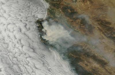
Satellite image Thursday, July 28, of smoke emitted from Soberanes Fire in Monterey County.
Satellite image Thursday, July 28, of smoke emitted from Soberanes Fire in Monterey County. (NASA Worldview)

Those factors have led to intensely smoky conditions in the fire zone that have occasionally limited the use of firefighting aircraft. Weather above the marine layer -- in terrain above an elevation of 500 to 1,000 feet east of Highway 1 -- has been sunny, hot and dry and, except for the relatively light winds, is ideal for burning. What's more, low humidity after nightfall -- often a time when moisture increases and fire behavior may moderate -- has offered little relief to firefighters. Little change in these conditions is expected in the coming days.

The fire has claimed one life so far. On Thursday, Cal Fire identified a bulldozer driver killed earlier this week as Robert Reagan III of Friant, a town just north of Fresno. Reagan reportedly suffered fatal injuries when his machine overturned on a steep slope.

lower waypoint
next waypoint