//www.youtube.com/watch?v=vW5jN5wErIc
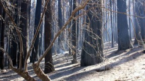
The Rim Fire burning near Yosemite National Park has consumed about 400 square miles, leaving some serious damage in its wake. On Tuesday, the Tuolumne River Trust released footage of the area, showing the terrain in 2008 and on-the-ground video taken last week. (The first two minutes of the video show the “before,” the second half shows the “after.”)
“In the short term, we’re looking at trees that have been burned down or fallen down, barren soils that are just primed for erosion when winter comes,” said Eric Wesselman of the Tuolumne River Trust.
A team of federal scientists with Burned Area Emergency Response (BAER) is currently surveying the burned zones to identify the worst erosion danger. Wesselman says on average, funding for BAER programs is about five percent of the overall fire cost. The Rim Fire recently topped $100 million.
“This is going to be tens of millions of dollars that we’re going to need for the recovery in the months and years ahead,” Wesselman said.