upper waypoint

Marin Fire Update: Crews Close to Full Containment of Mountainside Blaze

Save ArticleSave Article
Failed to save article

Please try again

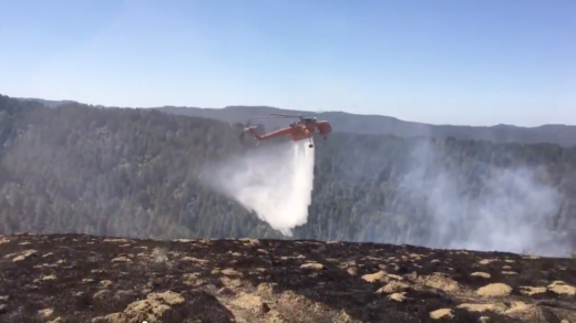
A Cal Fire helicopter makes a water drop Tuesday on the Irving Fire, in Samuel P. Taylor State Park on a ridge above the community of Lagunitas.  (Marin County Fire Department via Twitter)

Update, 9:20 a.m. Wednesday: The Marin County Fire Department says the Irving Fire, which started Monday evening, is 65 percent contained.

The department says its acreage estimate remains the same -- 152 acres -- and no further growth is expected. Full containment is expected by the end of the week.

Marin County Fire Chief Jason Weber told KQED's Ted Goldberg on Wednesday that investigators believe the fire was sparked by a downed PG&E power line on Barnabe Mountain.

Update, 10:50 p.m. Tuesday: The Marin County Fire Department has updated the stats and status for the Irving Fire:

  • After more careful mapping of the blaze, it's estimated to have burned 152 acres.
  • Containment has increased to 45 percent.
  • The Fire Department says it will be attending to hot spots amid drier, windier weather, and firefighters are expected to be on the scene, on Barnabe Mountain northwest of Lagunitas, through Thursday.

Update, 6:15 p.m. Tuesday: Marin County firefighters, aided by crews from several local fire departments and water drops by Cal Fire helicopters, say they're gaining the upper hand on a 115-acre blaze that started Monday evening near the community of Lagunitas.
Sponsored

The Marin County Fire Department says the Irving Fire is 35 percent contained and that the threat to nearby homes is subsiding. Firefighters from Tomales, Santa Rosa and Sonoma Valley have aided in the battle to contain the blaze.

The fire, which broke out about 7:30 p.m. Monday just below Barnabe Peak, a little more than a mile northwest of Lagunitas, prompted mandatory evacuations of several rural roads and was said to threaten 150 homes.

All evacuation orders were lifted late Monday afternoon, though the fire was still far from complete containment.

Update, 10:25 a.m. Tuesday: The Irving Fire burning a little more than a mile northwest of the community of Lagunitas has scorched approximately 115 acres and is 25 percent contained, the Marin Country Fire Department wrote in a tweet.

The Fire Department said the threat to homes near Samuel P. Taylor State Park still exists, but is decreasing, and evacuation orders will be re-evaluated by early afternoon Tuesday.

Original Post: Marin County officials Monday night ordered residents to evacuate hillside residences near Samuel P. Taylor State Park as local fire crews worked to contain a wildfire nearby.

The Irving Fire broke out early Monday evening high on the flank of 1,466-foot Barnabe Peak, a little more than a mile northwest of the community of Lagunitas.

The Marin County Fire Department said Tuesday morning the fire had burned 100 acres and was 10 percent contained. The agency said around 150 structures were threatened but none of them were damaged.

Residents on the sparsely populated ridge were ordered to leave as the fire spread through the evening. The roads ordered evacuated include: Mountain King Road, Portola Avenue and Alamo Way down to Barranca Road. Residents in other hillside areas of Lagunitas and Forest Knolls were advised early Tuesday that they may be ordered to leave.

Many residents of the affected area appeared to be taking advantage of an emergency shelter set up at Lagunitas School. The school is closed for the day Tuesday.

The Marin County Sheriff's Office ordered the closure of 8 miles of Sir Francis Drake Boulevard, from Nicasio Valley Road to Platform Bridge Road, to keep the twisting forest road free for firefighters.

The sheriff's office said on Facebook that while crews "are making great progress," heavy smoke was likely in parts of the county into Tuesday. Northwesterly winds were appeared to be pushing the heaviest smoke across the San Geronimo Valley and across the hills to Fairfax, San Anselmo and San Rafael.

The department also published a public information number: (415) 473-7191

lower waypoint
next waypoint