upper waypoint

Aided by Small Changes in Weather, Firefighters Continue to Battle Dixie Fire

Save ArticleSave Article
Failed to save article

Please try again

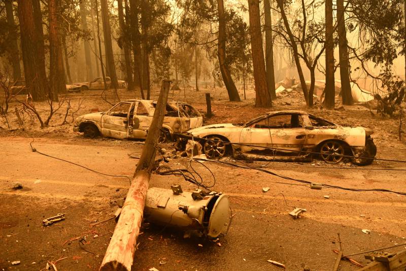
The charred remains of two cars after a fire passed by the area.
Power lines lay on the smoldering remains of vehicles during the Dixie Fire in an unincorporated area of Plumas County on July 25, 2021. (Josh Edelson/AFP via Getty Images)

Weather conditions Tuesday were helping at least temporarily to calm two gigantic wildfires burning along the West Coast. But there was bad news for a tiny California community savaged by flames last weekend, and property losses increased in Oregon.

Damage assessment teams have so far tallied 36 structures destroyed and seven damaged in Indian Falls, said Nick Truax, an incident commander for the massive Dixie Fire in the mountains of Northern California.

The assessment was about half complete, Truax said during an online briefing Monday night. The ability to safely tally damage depends on fire activity.

The Dixie Fire had scorched more than 325 square miles as of early Tuesday and was 23% contained. More than 10,000 homes were threatened in Plumas and Butte counties, a region about 175 miles northeast of San Francisco.

An inversion layer on Monday trapped smoke over much of the fire, and the shade helped lower temperatures and keep humidity up, incident meteorologist Julia Ruthford said.

Similar smoke conditions were expected through Tuesday. Monsoon moisture was streaming over the region but only light showers were likely on the fire. A return to hotter and drier conditions was forecast for later in the week.

The Dixie Fire, burning mostly on federal land, is among dozens of large blazes burning in the U.S.
Sponsored


Nickie Johnny, incident commander for the Dixie’s east section, said that with so many fires going on in the nation, use of federal resources has to be prioritized and she credited the assistance of local governments and Cal Fire.

“I just wanted to thank them for that because we are strapped federally with resources all over the nation,” she said.

Authorities were hopeful that cool temperatures, increased humidity and isolated showers will help them continue to make progress against the nation’s largest wildfire, the Bootleg Fire in southern Oregon. It was 53% contained after scorching 640 square miles of remote land.

“The mild weather will have a short-term calming effect on the fire behavior. But due to the extremely dry conditions and fuels, as the week progresses and temperatures rise, aggressive fire behavior is likely to quickly rebound,” the Tuesday morning situation report stated.

A new damage assessment found that the lightning-sparked fire has destroyed 161 residences, 247 outbuildings and 342 vehicles in Klamath and Lake counties, the report said, cautioning that the numbers could increase as firefighters work through interior of the fire area.

Related Coverage

In Montana, four firefighters were released from a hospital and a fifth was being treated at a burn center Monday after a wildfire overran them last week, authorities said. Crews were trying to keep the 10-square-mile Devil’s Creek Fire from reaching Fort Peck Reservoir along the Missouri River in Garfield County. It’s one of three major fires in Montana.

Firefighters have frequently dealt with perilous fire behavior, with flames consuming huge areas of vegetation each day. Such conditions are often from a combination of unusual random, short-term and natural weather patterns heightened by long-term, human-caused climate change. Global warming has made the West much warmer and drier.

Elsewhere in the state, the 106-square-mile Tamarack Fire south of Lake Tahoe continued to burn through timber and chaparral but firefighters made progress, aided by cooler weather.

The fire was 54% contained and evacuation orders that affected some 2,000 residents in 15 communities on both sides of the California-Nevada state line had been lifted. The fire, sparked by lightning on July 4 in Alpine County, has destroyed at least 23 buildings, including more than a dozen in Nevada.

Sponsored

lower waypoint
next waypoint