upper waypoint

Yosemite Fire 22% Contained, Sequoias So Far Unharmed

Save ArticleSave Article
Failed to save article

Please try again

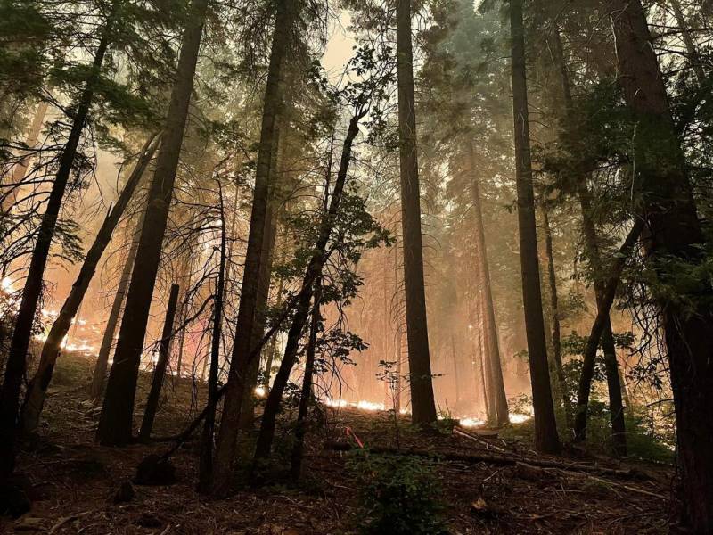
Fire amidst trees
The Washburn Fire as seen from along Highway 41 on July 9, 2022. (Courtesy of Yosemite Fire and Aviation)

Updated 11:00 a.m. Tuesday

California firefighters gained ground Monday in the battle against a wildfire that poses a threat to a grove of giant sequoias and a small community in Yosemite National Park.

The Washburn Fire on the western flank of the Sierra Nevada had scorched about 2,700 acres but was 22% contained as of Monday night, according to an incident update.


Campers and residents near the blaze were evacuated over the weekend, while the rest of the sprawling park remained open, though heavy smoke obscured scenic vistas and created unhealthy air quality.

“Today it’s actually the smokiest that we’ve seen,” Nancy Phillipe, a Yosemite fire information spokesperson, said Sunday. “Up until this morning, the park has not been in that unhealthy category, but that is where we are now.”

More than 500 mature sequoias were threatened in the Mariposa Grove, but as of Saturday afternoon there were no reports of severe damage to any named trees, including the 3,000-year-old Grizzly Giant.

Mariposa Grove and Yosemite Valley have been protected since President Abraham Lincoln signed legislation in 1864.

“Fortunately, the Mariposa Grove has a long history of prescribed burning and studies have shown that these efforts reduce the impacts of high-severity unwanted fire,” a National Park Service statement said.

The cause of the fire was under investigation.

Beyond the trees, the small community of Wawona, which is surrounded by park and a campground, was under threat, with people ordered to leave their homes and campsites on Friday night.

Phillipe said the park posted a video of a temporary sprinkler system installed to protect the trees. She said she’s confident that the sprinkler system combined with previous prescribed burns is the best protection for the trees. “If we were to add the additional foil protection, that would actually create a baked potato effect on the tree, and so we’re not doing that,” she said.

An estimated 1,600 people were evacuated, including a hotel, a campground and permanent residents. The Red Cross has set up a shelter in Mariposa, but Phillipe said most people who evacuated ended up not needing to go there.

“Folks coming into the park … just be aware that the air quality today is in the unhealthy range,” she said. “Our priorities remain: firefighters, public safety, the community of Wawona and the giant sequoias in the Mariposa Grove.”
Phillipe also said there are crews and aerial resources, including tankers and helicopters. The fire was proving difficult to contain, with firefighters throwing “every tactic imaginable” at it, she said, adding that that included air drops of fire retardant as well as the planned use of bulldozers to create fire lines, a tactic that’s rarely used in a wilderness setting like Yosemite.

The bulldozers would primarily be used to put in fire lines to protect Wawona, Phillipe said.

Though firefighters were facing hot and dry conditions, they didn’t have to contend with intense winds on Saturday, said Jeffrey Barlow, senior meteorologist with the National Weather Service in Hanford. Given the relatively small size of the fire and minimal winds, smoke impacts were not expected to stretch far beyond the park, he said.

The giant sequoias, native in only about 70 groves spread along the western slope of California’s Sierra Nevada range, were once considered impervious to flames but have become increasingly vulnerable as wildfires fueled by a buildup of undergrowth from a century of fire suppression and drought exacerbated by climate change have become more intense and destructive.

Lightning-sparked wildfires over the past two years have killed up to a fifth of the estimated 75,000 large sequoias, which are the biggest trees by volume.

There was no obvious natural spark for the fire that broke out Thursday next to the park’s Washburn Trail, Phillipe said. Smoke was reported by visitors walking in the grove that reopened in 2018 after a $40 million renovation that took three years.

The fire had grown from 700 acres on Saturday morning to 1,600 acres on Sunday morning.

A fierce windstorm ripped through the grove a year and a half ago and toppled 15 giant sequoias, along with countless other trees.

The downed trees, along with massive numbers of pines killed by bark beetles, provided ample fuel for the flames.

The park has used prescribed burns to clear brush around the sequoias, which helps protect them if flames spread farther into the grove.

Meanwhile, most evacuation orders were lifted Saturday in the Sierra foothills about 80 miles to the northwest of the Washburn Fire, where another fire broke out on July 4. The Electra Fire, which began near Jackson, was mostly contained, and only areas directly within the fire’s perimeter remained under evacuation orders, according to the California Department of Forestry and Fire Protection.

So far in 2022, over 35,000 wildfires have burned nearly 4.7 million acres in the U.S., according to the National Interagency Fire Center, well above average for both number of wildfires and acres burned.

Evacuations and closures

  • Wawona Road (Highway 41) south of Yosemite West, and the Mariposa Grove, are closed until further notice. Wawona Road  is also closed at the South Entrance north to Henness Ridge Road.
  • Yosemite West remains accessible via Wawona Road from the north (from Yosemite Valley). All other areas of Yosemite National Park are open.
  • Use Highways 140 or 120 to enter Yosemite. Expect smoky conditions within the park.
  • A map of the evacuation area and current evacuation levels is available here.

Evacuation shelter: New Life Christian Fellowship, 5089 Cole Road, Mariposa, CA 95338

This story has been corrected to fix inaccurate information from a park spokesperson and reflects that the tree trunks are not wrapped in protective foil.

KQED’s Lakshmi Sarah contributed to this report.

Sponsored

lower waypoint
next waypoint