upper waypoint

Bay Area Gets Taste of Dreaded Summer Combo: Soaring Temperatures and Drifting Wildfire Smoke

Save ArticleSave Article
Failed to save article

Please try again

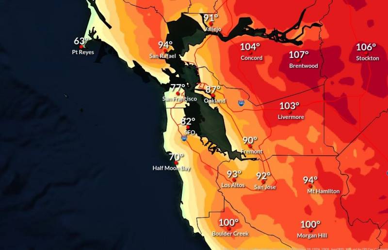
A weather map showing high temperatures throughout the eastern Bay Area and into the Central Valley.
The National Weather Service maximum temperature forecast for Tuesday, Aug. 16, showing a regional high of 107 in the eastern Contra Costa city of Brentwood. (National Weather Service San Francisco Bay Area office, via Twitter)

The Bay Area is experiencing an increasingly familiar summer cocktail of heat and wildfire smoke, a mixture that has prompted alerts from both the National Weather Service and regional air regulators.

As to the heat:

The National Weather Service San Francisco Bay Area office in Monterey posted a heat advisory through Tuesday evening for the region’s interior, where temperatures in some areas had climbed above 100 degrees by the early afternoon.

The weather service says eastern parts of Contra Costa and Alameda counties could see highs close to 110. Forecast extremes include 109 in Brentwood and 105 in Livermore. (See the end of this story for a partial list of cooling centers open on Tuesday across the region.)

Most of the rest of the region’s interior valleys, from Sonoma County south through Santa Clara County, will see temperatures in the high 90s.

Sponsored

Along the bay’s shore and coast, however, conditions will be downright humane, with highs from the 60s to 80s. Most of the Bay Area will see a pronounced cooldown beginning Wednesday and continuing through the weekend.

At 3 p.m., temperatures across the region ranged from the high 50s along the coast to the low 100s in the inland valleys. On the hot side: 105 in Brentwood, 102 in Livermore and Concord, 101 in Healdsburg and 99 in Santa Rosa. On the very cool side of the spectrum: 58 at Pacifica and Ocean Beach in San Francisco, 59 in El Granada on the San Mateo County coast, and 65 at Bolinas.

Most of interior California will not see any break from the heat until Saturday at the earliest, with triple-digit temperatures expected to linger across a 400-mile stretch of the Sacramento and San Joaquin valleys. In Redding, at the northern end of that stretch, the average high through Friday is forecast to be about 108. Bakersfield, at the opposite end of the great valley, is looking at an average high of about 104 for that same time frame.
As to air quality:

The Bay Area Air Quality Management District issued a Spare the Air alert Tuesday because of wildfire smoke drifting south from a series of lightning-sparked forest fires along the Humboldt-Trinity county line east of Eureka. The agency says the combination of wildfire smoke, vehicle exhaust and relatively stagnant conditions and high temperatures in the region set the stage for ozone to reach unhealthy levels.

But as of midday Tuesday, data from the agency showed ozone levels throughout much of the region in the green or “good” range. The level of fine particulates, however, was trending upward, with most of the agency’s official air monitors showing readings in the yellow or “moderate” range. The continuing effects of wildfire smoke prompted the district to issue an air quality advisory — but not a Spare the Air alert — for Wednesday.

Cooling centers

In response to the extreme heat, several Bay Area counties and local communities are listing free cooling center that will be open through at least Wednesday.

lower waypoint
next waypoint