upper waypoint

Unusually Early Cold Storm Dusts Sierra Nevada Peaks With Rare August Snow

Save ArticleSave Article
Failed to save article

Please try again

A view from the Base Camp at Palisades Tahoe at over 8000 feet on Saturday, Aug. 24, 2024. (Courtesy of Palisades Tahoe via X)

An unusually cold weather system Saturday brought snow to Washington state’s Mount Rainier and was forecast to bring a dusting to California’s Sierra Nevada.

The cold system from the Gulf of Alaska interrupted the West Coast’s summer, dropping down through the Pacific Northwest into Northern California. The National Weather Service on Saturday posted a photo of a white-covered peak from Rainier.

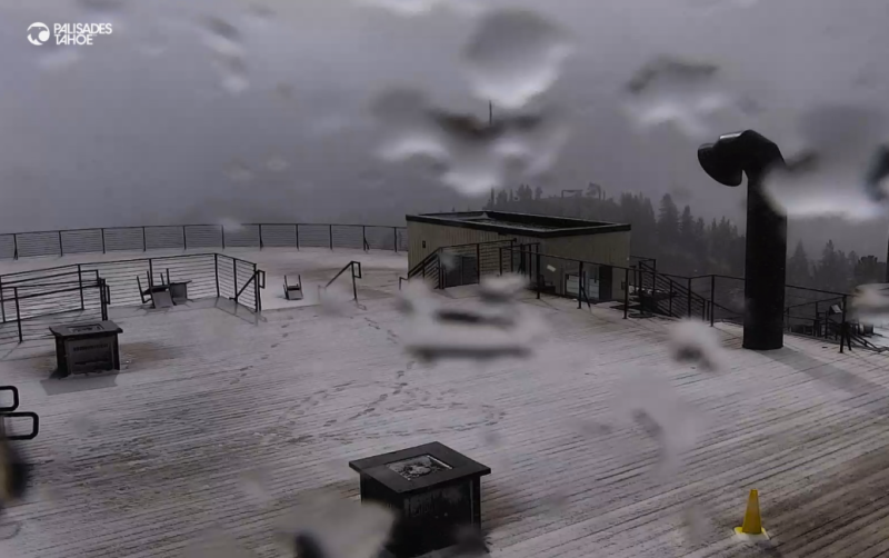
In California, light snow was seen at the Palisades Tahoe base camp at 8200 feet. It’s possible in the Sierra Nevada, mostly around Tioga Pass and higher elevations of Yosemite National Park, the National Weather Service said.

Sponsored

August snow has not occurred in those locations since 2003, forecasters said.

Tioga Pass rises to more than 9,900 feet and serves as the eastern entryway to Yosemite. But it is usually closed much of each year by winter snow that can take one or two months to clear.

“While this snow will not stay around very long, roads near Tioga Pass could be slick and any campers and hikers should prepare for winter conditions,” the weather service wrote.

While the start of ski season is at least several months away, the hint of winter was welcomed by resorts.

“It’s a cool and blustery August day here at Palisades Tahoe, as a storm that could bring our first snowfall of the season moves in this afternoon!” the resort said in a social media post Friday.

The “anomalous cool conditions” will spread over much of the western U.S. by Sunday morning, according to the National Weather Service’s Weather Prediction Center in College Park, Maryland.

Despite the expected precipitation, forecasters also warned of fire danger because of gusty winds associated with the passage of the cold front.

At the same time, a flash flood watch was issued for the burn scar of California’s largest wildfire so far this year from Friday morning through Saturday morning.

The Park Fire roared across more than 671 square miles after it erupted in late July near the Central Valley city of Chico and climbed up the western slope of the Sierra.

The fire became California’s fourth-largest on record, but it has been substantially tamed recently. Islands of vegetation continue to burn within its existing perimeter, but evacuation orders have been canceled.

California’s wildfire season got off to an intense start amid extreme July heat. Blazes fed on dried-out vegetation that grew during back-to-back wet years. Fire activity has recently fallen into a relative lull.

Forecasts call for a rapid return of summer heat as the cold front departs.

lower waypoint
next waypoint