upper waypoint

Oakland to Close 74 Miles of Streets to Cars Starting Saturday

Save ArticleSave Article
Failed to save article

Please try again

Now's a good time to find that old box of sidewalk chalk.

Oakland will begin to close 74 miles of its blacktop to cars starting Saturday, reserving roughly 10% of all streets in the city for pedestrians and bicyclists, as part of an effort to encourage social distancing and ease crowding in public spaces during the city's ongoing shelter-in-place order.

"We are giving Oaklanders more room to spread out safely," Mayor Libby Schaaf said Friday at a press conference in the Fruitvale District. "It's also a message to drive slowly and cautiously. We have got to eliminate car accidents. We have got to keep our health system open and ready for a surge that we believe is coming due to the coronavirus pandemic."

Click the image below for a larger version.

A map of streets that Oakland plans to close to cars while residents shelter in place. The first four street closures will begin on Saturday, April 11. Existing neighborhood bike routes and bike ways are represented by solid purple line; dotted lines represent proposed bike routes.
A map of streets that Oakland plans to close to cars while residents shelter in place. The first four street closures will begin on Saturday, April 11. Existing neighborhood bike routes and bike ways are represented by solid purple line; dotted lines represent proposed bike routes. (Oakland Department of Transportation)

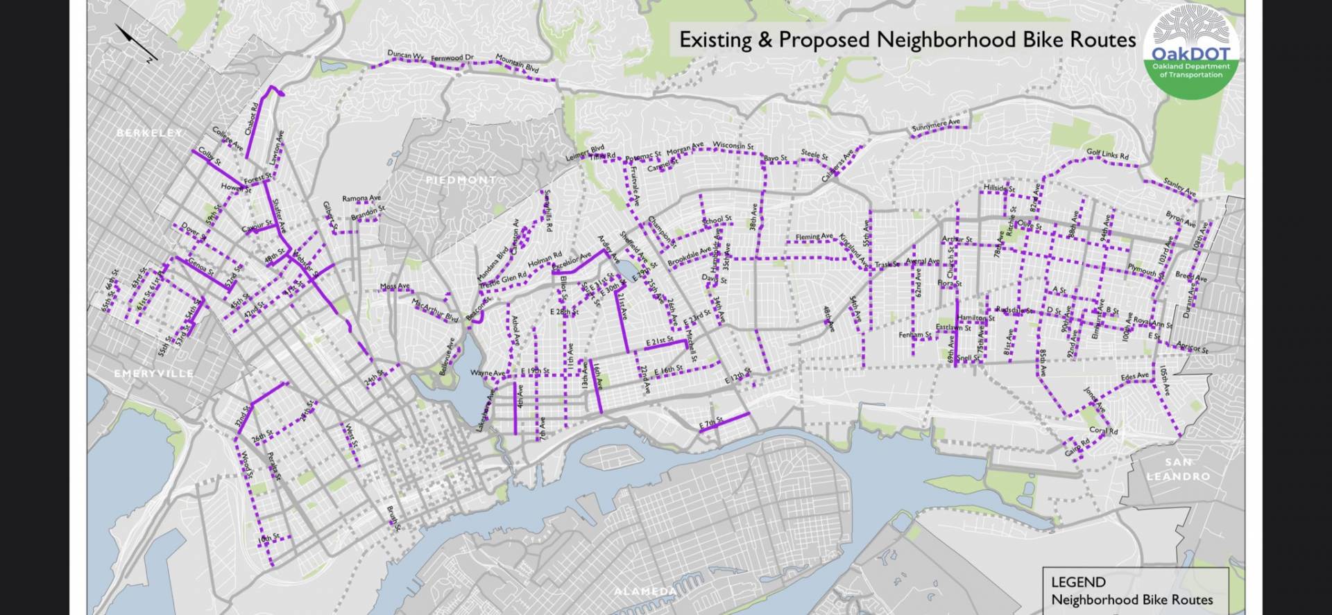
Located on all existing or proposed neighborhood bike routes, the proposed streets cut a wide swath across the city, running through just about every neighborhood, based on a map Schaaf displayed during a virtual town hall Thursday night. While the streets will be closed to through traffic, Schaaf noted that local residents and essential workers will still be allowed to drive in an out and said the city was not planning to ticket violators.

Schaaf did not elaborate on how the city planned to enforce the measure.

Sponsored

City officials said they plan to roll out the program incrementally, starting at four different locations on Saturday and shutting down additional streets to cars in other neighborhoods in the coming weeks. Signs and barricades will be placed at key intersections, with signage prioritized on routes in underserved communities, according to the city order.

The first set of streets include: West Street from West Grand Avenue to 14th Street; Arthur Street from Havenscourt Boulevard to 78th Avenue; E. 16th Street, from 23rd Avenue/Foothill Boulevard to Fruitvale Avenue; and 42nd Street, from Adeline Street to Broadway.

related coverage

The plan, called "Oakland Slow Streets," is modeled on a similar initiative in Denver, which closed some of its streets last week to ease overcrowding in city parks.

That effort comes as access to many regional parks in the area have been significantly limited to prevent crowding.

Before COVID-19 upended life as we knew it, a movement to make more streets car-free was gaining traction in a growing number of urban areas across the country, including San Francisco, which in January blocked private vehicles on the busiest stretches of Market Street.

Oakland, though, is the first Bay Area city to order widespread street closures during the current shelter-in-place period, and the announcement drew effusive praise from bicyclists and pedestrian advocates, who took immediately to social media to advocate for similar initiatives in neighboring cities.

During Thursday's town hall, Oakland's Chief Resilience Officer Alexandria McBride emphasized the need for more open space for residents.

"We know that the parks are becoming crowded," she said. "We also know that our streets and sidewalks make up about 25% of Oakland's land, and we wanted to take advantage of that resource."

KQED's Julia Scott contributed to this story.

lower waypoint
next waypoint