upper waypoint

Major 5.1 Earthquake East of San José Rattles Bay Area

Save ArticleSave Article
Failed to save article

Please try again

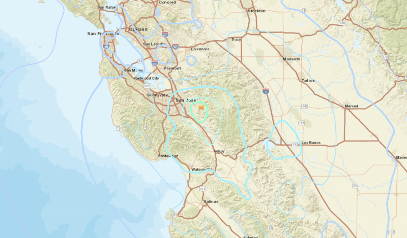
A screenshot of an earthquake map, showing a region in the the South Bay
A map showing the location of Tuesday morning's magnitude 5.1 earthquake, near San José. (U.S. Geological Survey)

A magnitude 5.1 earthquake, the Bay Area’s largest in eight years, hit the hills east of San José late Tuesday morning, rattling cities across a wide swath of the Bay Area and beyond, but ultimately inflicting little damage.

The quake struck at 11:42 a.m., roughly 12 miles from downtown San José, according to a preliminary estimate from the U.S. Geological Survey.

related coverage

A magnitude 2.9 aftershock followed five minutes later, the agency reported. A third, 3.5-magnitude quake was detected in the same area at 3:08 p.m., followed by a 2.8-magnitude quake at 5:20 p.m.

“The [5.1 magnitude] earthquake was widely felt, with over 18,000 ‘Did You Feel It?‘ reports submitted as of 1 p.m., extending from Central California north to Sacramento and Sonoma County,” Annemarie Baltay, a USGS seismologist, said in a video statement posted on Twitter. “Ground shaking appears to have been slightly less than our models expected for this magnitude earthquake.”

Baltay said there is a 1% chance of an aftershock greater than magnitude 5 in the next day, and perhaps as many as 15 smaller ones in the next week.

“We have good news to report, and that is that we’ve had no injuries to report, and no serious damage to any buildings,” said Santa Clara County Supervisor Cindy Chavez, who represents parts of San José. “That’s particularly important for our health care institutions, and all of them look like they’re in great shape.”

Source: US Geological Survey; map by Matthew Green/KQED

There were no immediate reports of damage or injuries, prompting a collective sigh of relief among officials in San José and other nearby cities that felt the brunt of the jolt.

The San José Fire Department said it had not received any earthquake-related calls. And Caltrain, Valley Transportation Authority and BART officials all said they briefly stopped service systemwide to conduct inspections, but soon resumed normal operations after not finding any damage.

Nearly 100,000 people reported receiving a warning before the shaking started, through California’s earthquake early warning system, according to the California Governor’s Office of Emergency Services, or Cal OES.

“Advance notice varied from two seconds for those very near the epicenter to 18 seconds for those in San Francisco,” the agency said.
The quake’s epicenter was detected at a depth of 4 miles, near the Calaveras Fault, in the vicinity of Joseph D. Grant County Park, a nearly 11,000-acre open-space expanse of rolling hills and oaks.

The 138-mile-long Calaveras Fault is a major branch of the San Andreas Fault and runs from San Juan Bautista in the south to San Ramon in the north.

Rich Constantine, mayor of Morgan Hill, south of San José, said he was in his kitchen when Tuesday’s “long and steady” quake struck.

“We had a frame in the house fall. Everything was shaking but once it stopped, there was no damage,” he said.

Constantine said Morgan Hill’s City Hall and other city offices were briefly evacuated but everyone returned to work soon after.

Striking just a week after the 33rd anniversary of the devastating 1989 Loma Prieta earthquake, Tuesday’s temblor is the largest to hit the Bay Area since 2014, when Napa was rocked by a 6.0 quake, according to USGS records.

Numerous moderate earthquakes have occurred along the Calaveras Fault, including the 6.2 Morgan Hill earthquake in 1984, and a 5.6 quake in 2007.

“I think it’s a reminder for all of us of the region,” San José City Councilmember Raul Peralez said, of Tuesday’s quake. “We know that we’re due for a big earthquake.”

This story includes additional reporting from KQED’s Guy Marzorati and Angela Corral, and The Associated Press.

Sponsored

lower waypoint
next waypoint