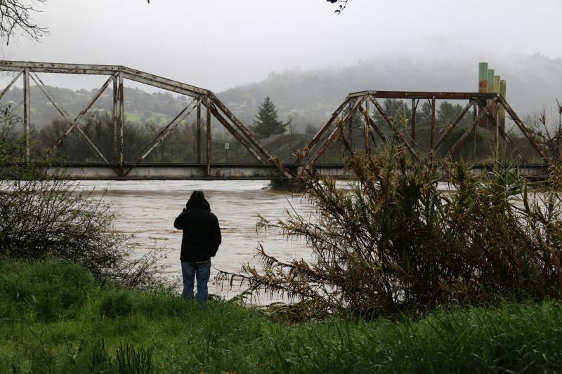
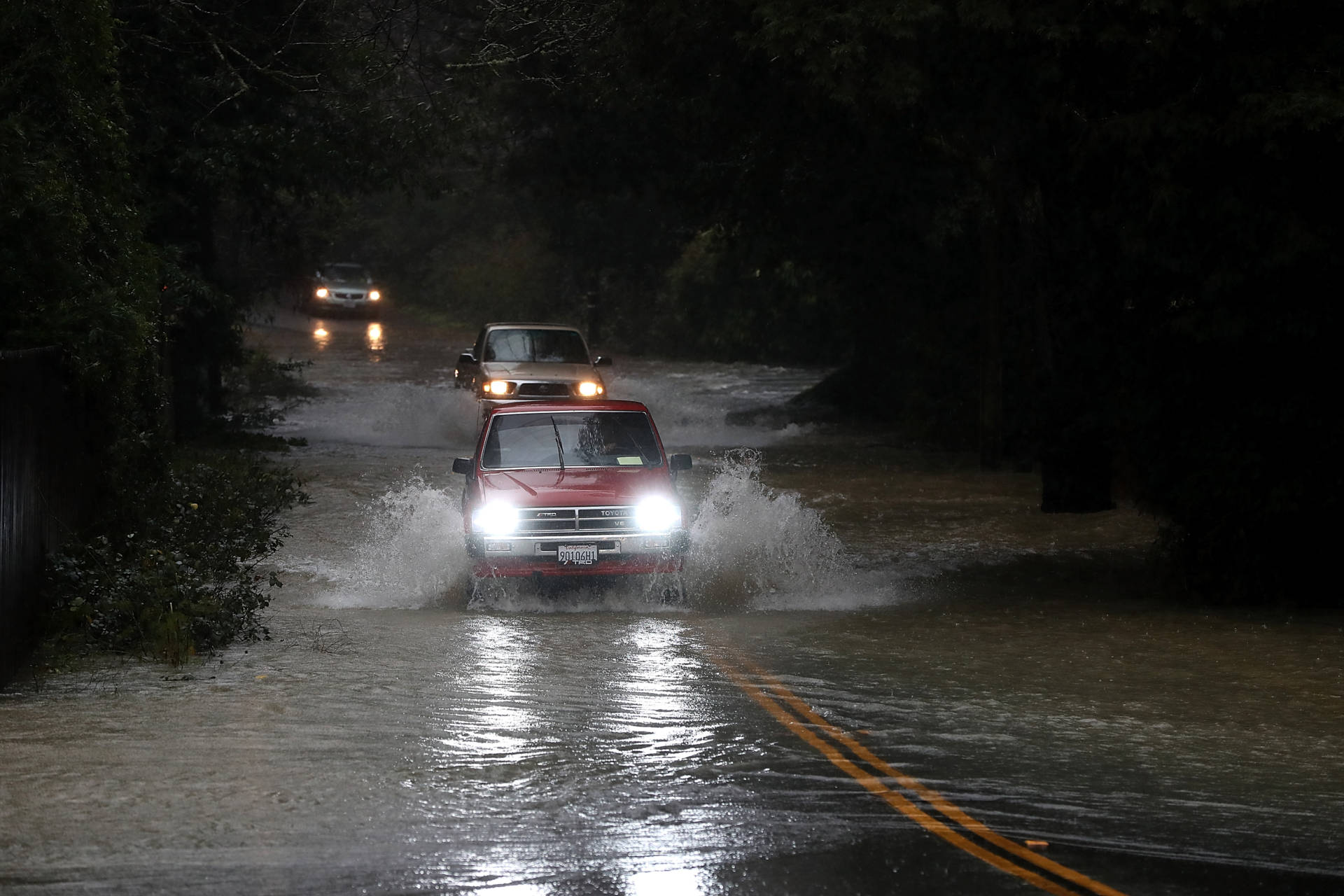
A man looks out at the flooding Russian River in Healdsburg on Feb. 27, 2019. An atmospheric river previously expected to only cause minor flooding this week has prompted flood advisories across the Bay Area. The massive system could bring thunderstorms and even a weak tornado. (Adam Grossberg/KQED)
Update, 4:20 p.m. Tuesday: A second atmospheric river is drenching the already-soaked Bay Area, compounding last weekend’s heavy rainfall. Relief is expected by tonight.
“We are going to see the Bay Area really clear out just after sunset, and it will be out of our region by around midnight,” said Brayden Murdock, a meteorologist at the weather service’s Bay Area office.
San Francisco and San Mateo counties are under a flood advisory until 5:15 p.m. for minor flooding in low-lying areas.
Sponsored
Over the past 24 hours, up to 2 inches of rain has fallen on the San Francisco region, and up to 1.5 inches are expected this afternoon. The weather service expects flooding in San Francisco, Daly City, San Mateo, Redwood City, Palo Alto, South San Francisco, San Bruno, Pacifica, Menlo Park, Foster City, Burlingame, San Carlos, East Palo Alto, Belmont, Millbrae, Half Moon Bay, Hillsborough, Atherton, Woodside and Highlands-Baywood Park.
Several roads in Marin County are closed due to flooding or landslides, including Shoreline Highway from Keyes Creek to Tomales, Levee Road from Shoreline Highway to Bear Valley Road, Platform Bridge-Sir Francis Drake Boulevard to Point Reyes and Petaluma Road, Shoreline Highway from Point Reyes to Olema Road.
In the past four days, Mount Tamalpais has soaked up over 16 inches of rain. Occidental saw nearly 15 inches, Santa Rosa as much as 6.5 inches and San Francisco and Oakland recorded about 3 inches, while San José received less than half an inch so far.
“Mount Tam has been kind of our big winner so far,” Murdock said.
A third system will sweep through the region on Thursday, but Murdock said it won’t bring rainfall as intense as previous storms.
“Out of what we’ve seen so far, this is going to be the lesser of these three surges in terms of rainfall,” Murdock said. “On Thursday, rain is not looking to be as heavy as what we’re currently seeing.”
Thursday’s storm will be colder, but flooding remains a concern after days of heavy rain. Coastal mountains could see .25 to 1 inch of rainfall before drier weather returns this weekend.
“It’s going to cool down, and we might see a little bit of snow up in the mountains, but it’s going to be a lot of rain on top of already saturated soils,” said Brian Garcia, warning coordination meteorologist with weather service’s Bay Area office.
Update, 2:49 p.m.: Tuesday’s heaviest rain is hitting Sonoma and Marin counties as the Bay Area’s second atmospheric river in a week intensifies with thunderstorms, and extreme precipitation is expected to cause flooding across the North Bay.
The agency predicts rapid river and stream rises will cause minor flooding in the region, partly due to a “line of thunderstorms from 7 miles south of Dillon Beach to 34 miles southwest of Point Reyes Station, including Tomales Bay and Stinson Beach,” forecasters wrote in a severe weather statement that was extended to 3 p.m.
The Sonoma County Sheriff’s Office said authorities responded to a mudslide in Forestville that carried an unoccupied home into the Russian River around 12:30 p.m. Deputies and firefighters evacuated homes in the area.
Forecasters note that up to 5 inches of rain have already fallen over the past day, and the atmospheric river will drop up to 1.5 more inches of precipitation, resulting in flooding at Point Reyes Station, San Geronimo, Tomales, Dillon Beach, Stinson Beach, Muir Beach, Tamalpais-Homestead Valley, Inverness, Lagunitas-Forest Knolls, Woodacre and Bolinas. Residents can expect water on roadways and overflowing drainages.
Meteorologists expect wind gusts of up to 70 mph will create “considerable tree damage” as well as damage to “homes, roofs and outbuildings.” Other places impacted include San Rafael, Novato, Mill Valley, San Anselmo, Larkspur, Corte Madera, Tiburon, Fairfax, Sausalito, San Geronimo, Lucas, Valley-Marinwood, Stinson Beach, Kentfield, Strawberry, Ross and Belvedere.
“Anyone outdoors should move to shelter inside a well-built structure and stay away from windows,” forecasters wrote. “Torrential rainfall is also occurring with these storms and may lead to flash flooding. Do not drive your vehicle through flooded roadways.”
“Overflowing poor drainage areas have already caused minor flooding in the advisory area. Between 2 and 6 inches of rain have fallen,” forecasters wrote in the advisory.
As a result, the agency expects minor flooding in low-lying and poor drainage areas, as well as water over roadways. Bolinas Road is closed from Azalea Hill to Highway 1 in West Marin due to debris on the roadway. Platform Bridge Road is closed to Sir Francis Drake Boulevard in West Marin due to localized flooding.
Parts of Marin County have received up to 5 inches of rain over the last 24 hours, and forecasters are still expecting a few inches more in the next three to six hours, said Brian Garcia, warning coordination meteorologist with the weather service’s Bay Area office.
The weather service wrote locations that “will experience flooding” include San Rafael to Novato, Mill Valley, San Anselmo, Larkspur, Corte Madera, Tiburon, Fairfax, Sausalito, Kentfield, Lucas Valley-Marinwood, Strawberry, Tamalpais-Homestead, Tamalpais-Homestead Valley, Ross, Belvedere and Santa Venetia.
Garcia said wind and rain will reach their peak in the North Bay on Tuesday afternoon and “then drag down south across the Bay Area.”
“The highest impacts are along the coast and the coastal ranges down across the Bay Area, probably through commute time,” he said.
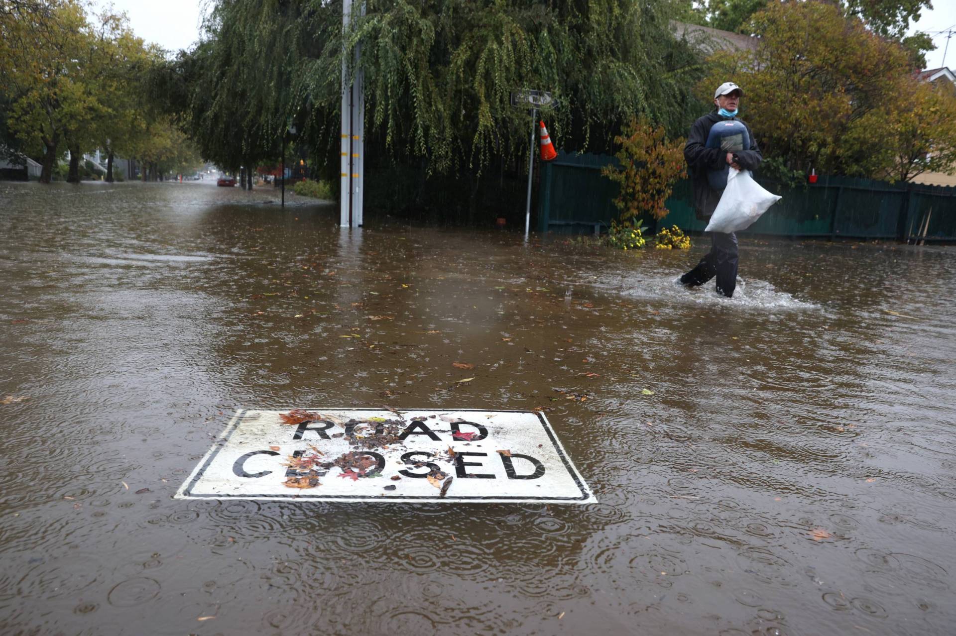
A “road closed” sign floats on a flooded street in San Rafael, California, on Oct. 24, 2021. (Justin Sullivan/Getty Images)
Original story, 10:15 a.m.: Tuesday morning’s atmospheric river storm has stalled over the Bay Area and could be stronger than was initially forecast, prompting flood advisories and bringing a chance of thunderstorms, strong winds and potentially a tornado warning.
The storm was previously expected only to cause minor flooding. Now, flood-inducing rain is forecast to affect the entire region for the rest of Tuesday, with the North Bay receiving the most. Waterways, including the Russian River, are expected to reach flood stage, according to the National Weather Service. A flood watch remains for the entire Bay Area through Wednesday at 4 a.m., and a wind advisory is in effect for much of the region.
“It’s kind of quasistalling wobbling between Mendocino and Marin,” said Brian Garcia, warning coordination meteorologist for the weather service’s Bay Area office, of the storm. “Stay informed today, especially if you are driving. It’s going to be dangerous.”
The potential for a “landfalling waterspout or weak tornado can not be ruled out,” according to the weather service’s morning memo.
“It’s definitely a non-zero chance that we could get a spin up in the North Bay and down through the peninsula,” Garcia said.
Garcia said San Francisco could also experience severe thunderstorm warnings, potential flash flood warnings and an “outsized” chance of a small tornado warning.
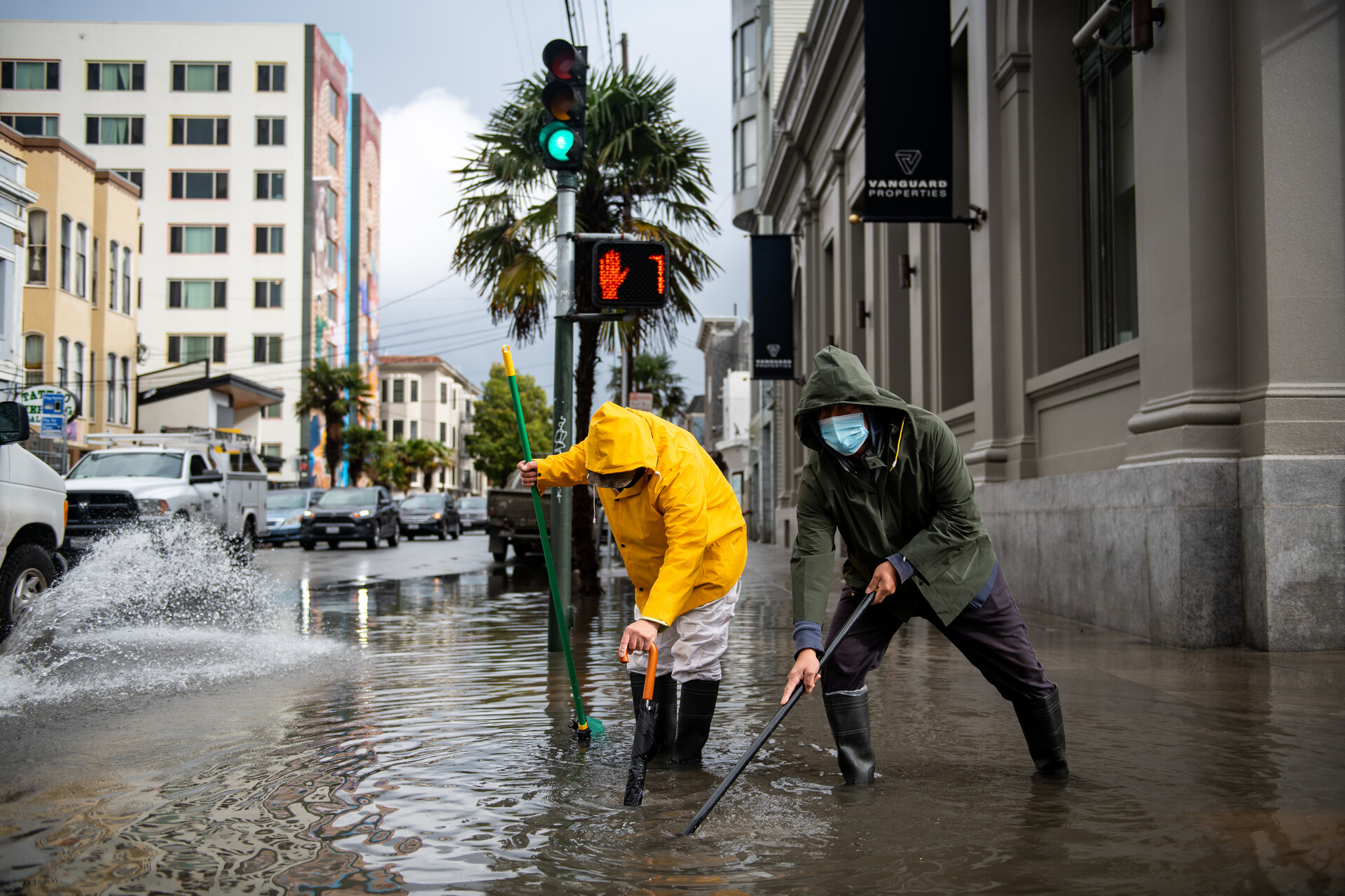
Two Mission District residents work to open a clogged drain on Mission and 21st streets in San Francisco on Jan. 10, 2023. (Beth LaBerge/KQED)
“This is one of those times where the people in the city really need to pay attention to what’s going on outside before venturing out because they could be putting themselves in harm’s way,” he said.
Jan Null, a certified consulting meteorologist at Golden Gate Weather Services, said the stormy weather somewhat mirrors November’s record-breaking storm, “where Interstate 80 seems to be a real sharp dividing line with the heavier activity.”
“It’s in those areas, especially the coastal mountains, where we could see some isolated thunderstorms,” he added.
Null said the storm has brought 60 mph winds to places like Mount Tamalpais and could bring equally strong winds again on Tuesday.
“We’re seeing one of those surges of energy now, and we’re going to see another one later on this afternoon with a bit of a lull sort of in the midday period,” he said.
San Francisco could see a little over 3 inches of rain, and parts of the North Bay have already received double-digit totals, Null said.
Green Valley Creek at Martinelli Road in Sonoma County has reached a moderate flood stage, and a flood warning is in effect for central Sonoma County. The Russian River at Guerneville and the Napa River at St. Helena could reach a minor flood stage either late Tuesday or early Wednesday. The weather service issued a flood warning for the Russian River for late Tuesday evening until further notice.
At least one school in Guerneville is closed because of the storm, and Sonoma County has alerted residents in multiple RV parks along the Russian River and creeks that flow into the waterway that flooding may occur, said Sam Wallis, deputy director of emergency management for Sonoma County.
Cars drive on a flooded road in Guerneville in January 2017. The Russian River town is just downstream from Venado, a site in the northern Sonoma County hills that is one of the rainiest locations in California. On Tuesday, at least one school in Guerneville closed because of the storm, and Sonoma County has alerted residents in multiple RV parks along the Russian River and creeks that flow into the waterway that flooding may occur. (Justin Sullivan/Getty Images)
“We’re in the process of alerting them and letting them know that they’ve got an issue and should move to higher ground,” Wallis said. “Because we’ve had a relatively wet winter, we are beginning to see downed trees and some landslides.”
After the November storm that wreaked havoc on Sonoma County, killing at least two people, Wallis said the county is paying close attention to how the two atmospheric rivers develop this week.
“One of the things we learned in November is that the situation can change drastically and quickly,” he said. “We are watching this very carefully. We’ve already seen a change, but it’s not in the same category as the November floods.”
Meteorologists expect Tuesday’s storm to lose momentum overnight before a short reprieve on Wednesday. On Thursday, another atmospheric storm, although smaller, will pummel the region.
“Anything that falls on Thursday is just going to be pure runoff,” Garcia said. “So we could go into flood much easier.”
Sponsored
lower waypoint
Stay in touch. Sign up for our daily newsletter.
To learn more about how we use your information, please read our privacy policy.
The PBS NewsHour is an hour-long evening news broadcast, hosted by Amna Nawaz and Geoff Bennett, which offers news updates, analysis, live studio interviews, discussions and more.