upper waypoint

In California’s Bone-Dry Eastern Sierra, a Spring Wildfire Burns Rapidly

Save ArticleSave Article
Failed to save article

Please try again

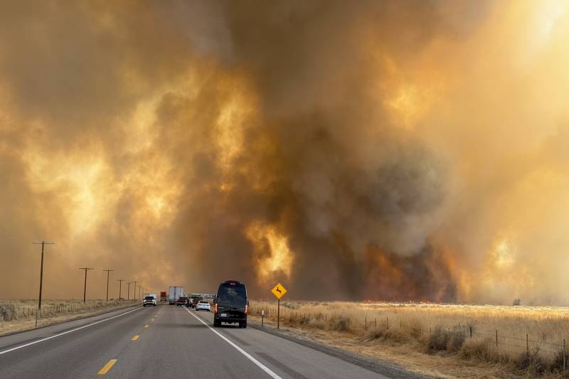
The Silver Fire burns near Highway 6 on March 30, 2025. The wildfire, which sparked Sunday afternoon near Bishop, has forced the evacuation of hundreds of homes and threatens important natural habitats. (Courtesy of California Highway Patrol)

Although Northern California has seen weeks of rainy weather, it’s a different story in the mountains south of Mammoth Lakes, where conditions have already dried out enough to fuel a powerful wildfire, threatening homes and infrastructure.

The Silver Fire, which sparked Sunday afternoon near the Eastern Sierra city of Bishop, had burned 1,250 acres as of Monday morning. Eight hundred homes — about one in every hundred across Inyo County — were under evacuation orders on Monday after fire intensity ramped up overnight, according to Cal Fire spokesperson Chloe Castillo.

“That is pretty significant,” she said. Additional evacuations have been ordered in Chalfant, a community to the north in Mono County.

Sponsored

The growing blaze is threatening critical infrastructure, watersheds and endangered species’ habitats in the rural area, including the White Mountain Research Center, Castillo said.

There is a long list of “natural resources that are out there that [firefighters] are attempting to save,” she told KQED.

As of Monday morning, the fire was 0% contained, and crews are expected to face challenges gaining containment throughout the day since the wind is gusting up to 65 mph in the area.

Castillo said that in the Eastern Sierra, winds are also prone to change directions quickly, making it difficult for firefighters to predict where resources will be needed. “When it’s mixed with fire, you end up with this probability of a fire that’s burning in multiple different directions,” she said.

“The outlook with the wind is pretty grim,” she told KQED. On Sunday, the fire was initially burning toward the east. But within two hours, it whipped around and started burning toward the north.

Unlike farther north in the Sierra Nevada, where 2 feet of snow is expected by Tuesday, the mountains that span between Yosemite and Death Valley national parks are nearly bone-dry.

Castillo said it’s not uncommon for the region to have wildfires in the early spring, especially this year, since the last 18 months have been incredibly dry.

Bishop has only gotten 3.36 inches of rain since October, while the western flank of the Sierra has hit closer to 11 inches. Much like Los Angeles, where massive wildfires destroyed entire neighborhoods in January, the area around Bishop didn’t benefit from the storms that gave Northern California rainfall totals a boost in November and December and again in February and March.

“In the winter into the spring in the Owens Valley, they have not had a whole lot of rain,” Castillo said. “The lack of moisture over the last year and a half has led to some really dry fuel building up in that area.”

Castillo said that Laws, the unincorporated area of Inyo County where the fire sparked, has several layers of underlying vegetation that have died and dried up, making it “ripe for burning.”

Other parts of the valley are at a similar risk, she said.

“Alabama Hills, the areas around Independence, those areas all have a lot of vegetation that need to be thinned out,” she told KQED, adding that due to repeated wind events, it’s been difficult to do vegetation management work.

“A lot of areas in the Owens Valley have a lot of heavy fuel loading, and the potential for burning is very high,” according to Castillo.
lower waypoint
next waypoint