upper waypoint

How California Water Suppliers Are Getting Earthquake-Ready

Save ArticleSave Article
Failed to save article

Please try again

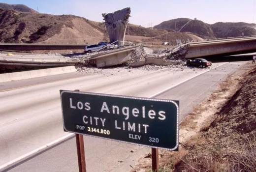
Aftermath of the 1994 Northridge earthquake in Southern California. (David Butow/Corbis via Getty Images)

As is often said, it’s not a matter of if, but of when, a large earthquake strikes the heart of one of California’s most densely populated regions. State officials and local agencies know the clock is ticking, and mile by mile, pipe by pipe, work crews are replacing or retrofitting water lines throughout much of the Los Angeles and San Francisco Bay areas. Upgrades have also been made in the Sacramento-San Joaquin Delta, the heart of the state’s water distribution system, where potential levee ruptures have made water officials uneasy for decades.

The San Andreas Fault, which generated the 1906 (7.9 magnitude) and the 1989 (6.9 magnitude) Bay Area earthquakes, could potentially produce a quake greater than 8.0. However, the Hayward Fault is widely considered the greater threat at this moment in geologic time. Scientists consider a 7.0 magnitude quake to be the largest likely to occur on the Hayward Fault, an offshoot of the San Andreas that runs through San Jose, Oakland, Berkeley and Richmond. The Hayward Fault hasn’t slipped significantly since 1868, and experts say it’s overdue for the proverbial “Big One.”

In the historical and global context, 7.0 isn’t huge, but if it strikes a heavily populated area, the damage could be significant. About 5,000 water connections that cross the Hayward Fault, as well as several critical water mains, could potentially be sheared in half by a powerful temblor, according to Richard Sykes, director of natural resources for the East Bay Municipal Utility District. That’s just within East Bay MUD’s service area. San Francisco’s water supply, sourced from Hetch Hetchy Reservoir in Yosemite National Park, also travels through large pipes that cross major East Bay fault zones. Several of its reservoirs, including Crystal Springs, San Andreas and Calaveras, sit literally on the San Andreas and Calaveras faults, with the water actually contained within the linear depressions created by these tectonic plate boundaries.

“It’s sort of a joke here that two of our reservoirs are named after faults,” said Steven Ritchie, the San Francisco Public Utilities Commission’s assistant general manager for water.

To protect the water supply of their collective 4 million customers, both East Bay MUD and the San Francisco PUC have protected their water mains with clever engineering systems that allow the earth to shift around the pipes, which range from 6 to 9ft in diameter, without damaging them. One of the San Francisco PUC’s major pipes is fitted with ball joints and slip joints that allow the steel-lined tube to shift and move without breaking.
Sponsored

San Francisco PUC’s ongoing upgrades are part of the $4.8 billion Regional Management Program, of which a key element is major seismic upgrades.

Among East Bay MUD’s major supply pipes, critical sections in high-risk fault zones have been retrofitted so they can shift and flex within spacious concrete tunnels.

“The pipe is on rollers so that when that offset occurs, it can move with the shifting earth,” said Andrea Pook, an East Bay MUD spokesperson, referring to a 2,000ft section of pipeline bored through the East Bay Hills.

“That tunnel could actually shear, but without shearing the pipe itself,” Sykes added.

For the unlikely event that the main water line is ruptured, East Bay MUDkeeps a six-month supply of reservoir water ready on the west side of the hills.

In Southern California, the Metropolitan Water District also has a six-month backup supply of water at hand, stored in reservoirs on the west side of the San Andreas Fault.

“That will buy us time to make any necessary repairs,” said Gordon Johnson, Metropolitan’s chief engineer.

He said his district began seriously seismically upgrading reservoirs, dams and various structures following the San Fernando earthquake of 1971, an early morning 6.7 magnitude quake that tore the region apart, killing 64 people and destroying freeways, sewer lines and thousands of buildings.

Now, he said, the agency – which delivers water to about 12 million people – is working on strengthening canals, aqueducts and pipelines. The district, in conjunction with the California Department of Water Resources and the City of Los Angeles, has formed a “seismic task force” that is currently identifying weak spots in the local water supply system and developing emergency response plans.

The preparations include stockpiling repair equipment and materials near likely rupture locations on numerous local faults. And two projects now in the works aim to seismically protect the Colorado River Aqueduct, as well as a 7ft-wide pipe that delivers treated water to several million people north of Long Beach.

The federal government also has its eye on California and its shifting tectonic plates. The U.S. Bureau of Reclamation has seismically retrofitted seven dams, according to Steve Melavic, the agency’s mid-Pacific region chief engineer. More upgrades, he said, are in the works.

Meanwhile, the California Division of Safety of Dams has mandated extensive upgrades to dams. Over the past two decades, inspections by the state agency – a branch of the Department of Water Resources – have resulted in dam owners spending more than $1.5 billion on repairing and upgrading dams to protect them from seismic risks, according to Erin Mellon, a spokesperson with the Department of Water Resources. Experts with her agency were unavailable for a phone interview, and questions sent via email about seismic upgrades in the Sacramento-San Joaquin Delta were not answered.

According to Sykes at East Bay MUD, the Department of Water Resources has provided his district with a $35 million grant to upgrade Delta levees that specifically protect the Mokelumne Aqueduct, which passes through the estuary. Sykes said upgrades to levees are generally made in accordance to the standards of the U.S. Army Corps of Engineers.

At the University of California, Los Angeles, Scott Brandenberg, a professor in the Department of Civil and Environmental Engineering, has extensively studied the delta and its levees. He said the earthen barriers, which protect and contain more than 1,000 maze-like miles of critical water supply channels, are not threatened as much by the Hayward and San Andreas faults as they are by more localized ones like the Dunnigan Hills Fault, the Gordon Valley Fault and the Midland Fault.

“These faults wouldn’t be capable of producing a 7.8 earthquake, like the San Andreas, but they could still cause strong shaking and serious damage,” he said.

One or more levee ruptures in the Delta could potentially flood freshwater supplies with saltwater – which would be a disaster for the state. These levees are vulnerable for a variety of reasons. For one, Brandenberg said, many were built on peat, which is soft and can become more so during an earthquake. In places, the levees are built of sand, which can essentially liquefy during intense shaking.

“I don’t think any improvements to these levees have made them earthquake-proof,” he said.

All in all, he said, the system is very fragile. In fact, the Delta’s vulnerability to earthquake damage is among the main arguments for building the controversial Delta tunnels. This system would move water under the Delta and connect it to the pumps at the south edge.

“It’s much easier to protect and maintain a system like that,” Brandenberg said.

Sponsored

This article originally appeared on Water Deeply, and you can find it here. For important news about the California drought, you can sign up to the Water Deeply email list.

lower waypoint
next waypoint