upper waypoint

Holiday Weekend Storms On Tap Could Bring Flooding to the Bay Area

Save ArticleSave Article
Failed to save article

Please try again

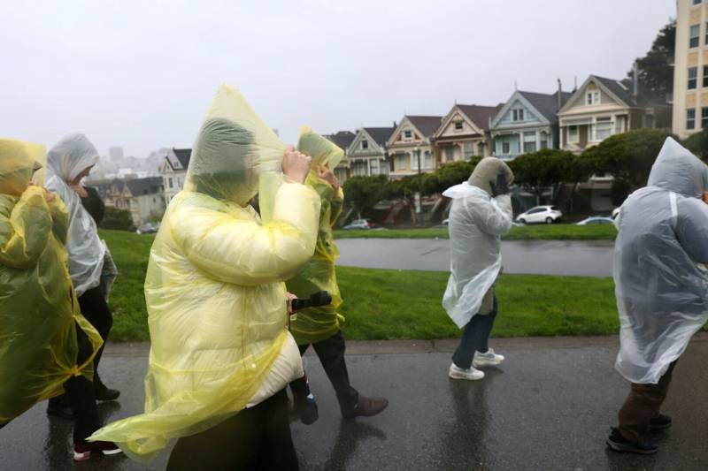
Several people wearing rain ponchos walk outside as the wind blows.
A group of tourists walk through Alamo Square Park during a storm in San Francisco on Feb. 4, 2024. (Beth LaBerge/KQED)

Updated, 1 p.m. Sunday:

A strong storm with heavy rain is expected to hit the Bay Area around midday and continue through the night. According to the National Weather Service, strong winds that could knock down trees, a high surf, thunderstorms and potential flooding will last through Monday with conditions improving to lingering showers on Tuesday.

The atmospheric river could bring two to five inches of rain to some Bay Area cities on Sunday afternoon and a flood watch will be in effect until Wednesday morning. In anticipation of potential landslides and other storm hazards, some parks in San Mateo County including Memorial Park have closed on Sunday.

Updated, 1 p.m. Saturday:

Sponsored

As the first of two moderate atmospheric rivers begin to roll over the region, the National Weather Service has issued a flood watch for the Bay Area and the Central Coast from Sunday through Wednesday morning. The advisory includes concerns about rising creeks, rivers and streams and the increased risk of shallow landslides.

A high surf advisory has been issued by the National Weather Service’s Bay Area office for all West-facing beaches from Sonoma County down to Monterey County. The high surf advisory will be in effect from 10 a.m. Saturday through 4 p.m. Sunday, with large breaking waves of 18 to 22 feet expected.

Dalton Behringer, a meteorologist with the weather service’s Bay Area office, said Saturday’s storm is “priming the pump” for potential flooding later in the weekend and into early next week. He said most parts of the Bay Area should expect between 1 and 3 inches of rain, and 6 to 8 inches could fall in coastal mountain ranges near Santa Cruz and Marin counties.

“That’s going to help the soils get closer to saturation if they’re not already, and we will likely be dealing with numerous shallow landslides and minor urban flooding,” he said. “I would expect some trees down and power outages due to the wind.”

He said Saturday’s storm could contain wind gusts of up to 30 mph, and Sunday’s storm could have gusts of up to 35 mph along the coast and higher elevations. However, stronger lowland winds are possible in the Santa Clara and Salinas valleys.

Behringer said he is most concerned about the Russian River near Guerneville because meteorologists forecast the North Bay to receive more rain than most places in the region. He said the Russian River has a 20% chance of reaching a lower flood stage.

UCLA climate scientist Daniel Swain said the Bay Area “could be under the gun for a good 24 to 48 hours.” He is concerned that either storm could stall over an already saturated area.

“If you get those embedded heavy rain bands that stay over the same spot for a long time, that relatively modest storm by other means can potentially produce significant flooding,” he said.

Update, 2 p.m. Thursday:

Meteorologists are now forecasting two moderate atmospheric river storms will move over the Bay Area and into the Sierra Nevada over President’s Day Weekend, beginning with a weaker storm late Friday night. The first deluge could drop an inch of rain in populated areas of the region and up to 3 inches in the coastal range.

“The second one is coming on the heels of the first one,” said Chad Hecht, a meteorologist at the Center for Western Weather and Water Extremes at the University of California, San Diego’s Scripps Institution of Oceanography.

“When you compound these storms, you tend to get a more exacerbated hydrologic response. Things like the ground saturated and heavy winds toppling trees.”

Hecht said the first storm would last about 24 hours and is forecasted to land in Northern California before working down the central coast. Forecasters expect Sunday’s storm to linger a few days and make landfall along the Central Coast, but Hecht said the Bay could still feel its effects because of the storm’s large size.

The National Weather Service’s Bay Area office forecasts high surf Saturday and Sunday with waves of 12 feet or larger from Monterey County to the San Francisco peninsula to the North Bay.

“We could see locally higher breaking waves up to 28 feet,” NWS meteorologist Dalton Behringer said.

“The west and southwest-facing beaches are going to be the most impacted,” he said. “The typical hotspots like Mavericks.”

He said both storms could bring wind gusts up to 40 mph along the coast and in more populated areas up to 35 mph. Behringer doesn’t expect extreme flooding since he forecasts the storms will occur over several days.

“We’re going to be looking at minor, shallow landslides for much of the area,” he said. “The good news is that rivers still have quite a bit of capacity to take the runoff.”

Behringer said the highest likelihood of any flooding issues due to streams or rivers rising is in the North Bay. But Hecht, with Scripps, said it is too early to tell where the worst storm effects will be.

“There is potential for some rivers to rise above flood stage with these storms,” Hecht said. “The exact location of where the heaviest precipitation will fall or what rivers will flood is hard to nail down, but the potential is there.”

Meteorologists forecast as much as 3 feet of snow falling on the Sierra Nevada between storms. The worst of the wintery conditions could come Sunday through Tuesday morning, coinciding with President’s Day this weekend.
“If you’re planning on traveling Monday into Tuesday, we would advise against it because that’s when we are expecting heavy mountain snow,” said Chelsea Peters, an NWS Sacramento meteorologist.

Original story, Feb. 13:

The National Weather Service forecasts three storms of varying intensities will roll through the Bay Area this week, starting with a relatively weak storm on Wednesday that could include some light rain, followed by a couple of stronger storms during the long President’s Day weekend.

Forecasters expect three-quarters of an inch of rain across most of the region on Wednesday, with more than an inch expected to fall in the North Bay and Santa Cruz mountains. Over the weekend through early next week, NWS Bay Area meteorologist Roger Gass said as much as 6 inches of rain could fall along the coastal range. San Francisco could receive 2.5 inches of rain.

While those numbers seem high, Gass cautioned that “we’re talking about [over] the course of several days. So it’s not all going to come at one time.”

That could mean that the impact of the storm won’t be as extreme, although just how intense Sunday’s storm will be is still up in the air.

“We’re still trying to fine-tune the details, but, again, it’s not expected to be as strong as the last system,” Gass said of the storm a week and a half ago that pounded the region with rain.

The three storms combined could add several feet of snow to the Sierra Nevada, and meteorologists advise holiday travelers to take extra precautions when visiting places like Tahoe or Yosemite National Park.

Meteorologists expect significant snow to fall on the Sierra Saturday through Tuesday morning, with as much as 3 feet of snow at higher elevations. The storms coincide with the holiday weekend, and forecasters warn that getting out of the mountains on Monday could be a harrowing experience.

Related Stories

“If you plan to travel, just be prepared for possible closures, chain controls and difficult driving conditions,” said Nathan Rick, a meteorologist with NWS Sacramento. “Definitely have some alternative plans in place again if you can.”

The storms aren’t quite atmospheric rivers — which can dump multiple inches of rain over a short period — but have some characteristics of these storms, mainly that the storms could encompass much of the state.

“It’s going to be probably more or less an equal opportunity event,” UCLA climate scientist Daniel Swain said in a Monday briefing. “It’s going to affect most of the state simultaneously.”

Swain said the weekend storms could produce “very wet conditions across most of the state.” He adds there’s a possibility of strong winds, “although almost certainly not as strong as what we saw last week in terms of wind” when gusts reached more than 90 mph in some places.

The trio of storms could bring flooding and landslides, especially as each deluge intensifies into next week. Swain said there could be flood concerns in Northern California because recent storms saturated much of the region.

“The difference is this one is coming fairly close on the heels of the previous very wet storm cycle,” he said. “It is now wet enough that a big storm cycle is going to start to result in larger flood-related impacts and the higher risk of landslides because the soil column is starting to become saturated at a deeper level.”

Sponsored

In the Bay Area, meteorologists forecast nuisance flooding in local streams and drainages but not necessarily major rivers.

lower waypoint
next waypoint