upper waypoint
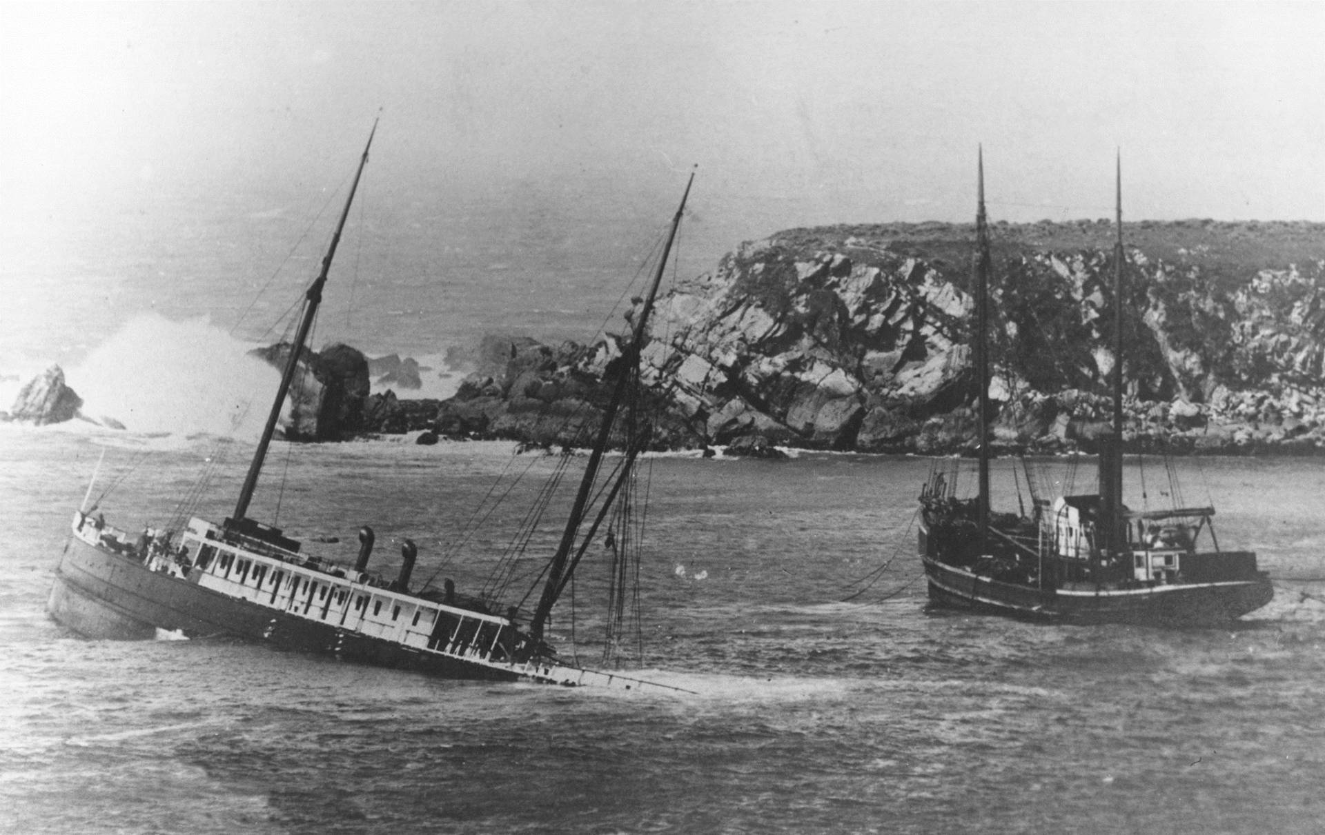
The 225-foot long steel-hulled coastal steamship Pomona sinks off Fort Ross cove on March 17, 1908 after hitting a submerged pinnacle.  Fort Ross Conservancy
The 225-foot long steel-hulled coastal steamship Pomona sinks off Fort Ross cove on March 17, 1908 after hitting a submerged pinnacle.  (Fort Ross Conservancy)

Exploring Historic Shipwrecks Along California's Redwood Coast

Exploring Historic Shipwrecks Along California's Redwood Coast

Save ArticleSave Article
Failed to save article

Please try again

Traveling along the seafloor, 2,600 feet beneath the surface, a remotely operated vessel approaches a shipwreck that’s not been seen in 65 years.

Swimming through the jellyfish and ctenophore-flecked waters, the ROV’s cameras focus on a ship, the USS Independence. It’s encrusted with sea life -- nature quickly colonizes all in its domain -- yet many features are still intact on the deck of this World War II-era aircraft carrier.

Independence was part of the U.S. Pacific Fleet, and in October 1944 was part of the Battle of Leyte Gulf, the largest naval battle in modern history. Fought to support the liberation of the Philippines from Japanese occupation, the battle was a decisive victory for the Allies against the Japanese Navy.

After the war, the ship was used as a target in Operation Crossroads, to test the impacts of nuclear weapons at Bikini Atoll. The U.S. Navy scuttled the heavily damaged carrier in 1951, not far from the Farallon Islands. It has been there ever since.

Finding and exploring Independence was a joint project between the Ocean Exploration Trust, a Connecticut organization founded by famed underwater explorer Robert Ballard, the National Oceanic and Atmospheric Administration, and Naval History and Heritage Command. The remotely operated vehicles Hercules and Argus were both part of the Titanic exploration.
Sponsored

But this fresh look at Independence has just been one part of the search for maritime artifacts along the Northern Californian coast this summer.

In early August, James Delgado, director of the NOAA's Maritime Heritage Program, stands on a bluff at Fort Ross Historic State Park, about a three-hour drive north of San Francisco. It's an area that has long attracted people to the coastline.

"For thousands of years this environment has nurtured people," says Delgado. "Its rich offshore nutrients have made the marine mammals thrive, along with fish. And so, for the Kashia (band of Pomo) and their ancestors, they certainly have used these waters. The Russians came by sea and settled here."

In the early 1800s, Russian settlers hunted marine mammals at Fort Ross, primarily selling otter pelts. By the middle of the century, though, otter populations crashed, and most Russians returned to their homeland. So, the main industry became timber.

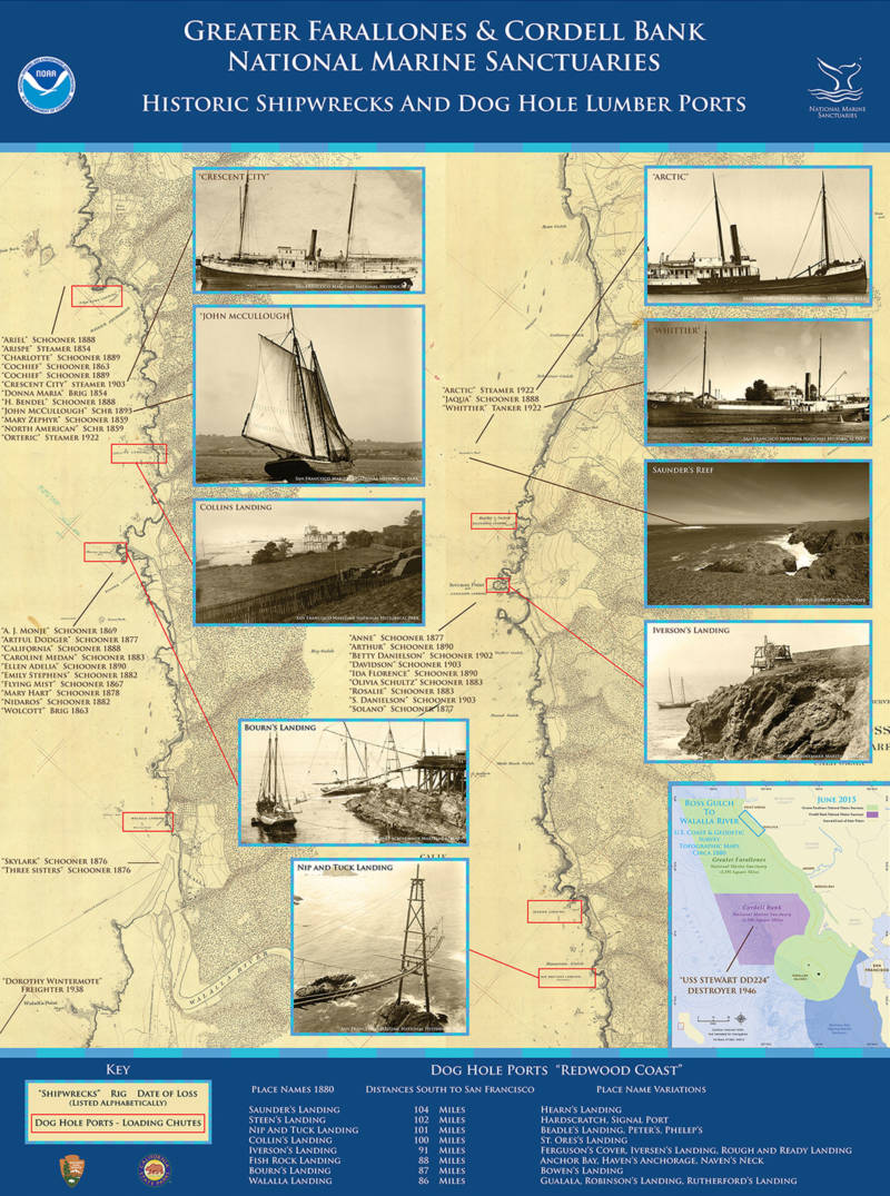
A map of shipwrecks and doghole ports in Cordell Bank and Greater Farallones National Marine Sanctuaries.
A map of shipwrecks and doghole ports in Cordell Bank and Greater Farallones National Marine Sanctuaries. (Robert Schwemmer, NOAA ONMS)

"I don't know if the average person realizes what an active area this was back in the 19th century and turn of the century," says Deborah Marx, a maritime archaeologist with NOAA. "Schooners were traveling up and down the coast, shipping this lumber, mainly to San Francisco."

Sonoma and Mendocino redwood ended up around the globe, attractive because it is so resistant to rot.

"It was moved onto larger vessels and shipped all over the world," says Marx.  "They shipped it to Hong Kong, China, Australia, South America. And so our lumber industry here really fueled the development of lots of these countries. It was essential for the building of the railroads. You wanted a very durable hardwood that would last especially in the hot humid conditions, in places like South America."

To support that industry, tiny ports known as "doghole ports" (so named because a dog could barely turn around in them) popped up along the coast: Duncans Mills, Timber Cove and Salt Point Landing are a few of the places still known today.

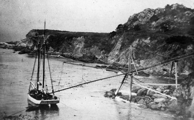
At the ports, loggers and mariners set up elaborate timber chutes to transfer cargo from the shore directly to the deck of a ship anchored near the coast at a mooring. It was easy for things to go wrong.

"If you're anchored in and a storm comes up, then you're going to get pushed into the rocks. And in that way a lot of these ships were lost," says Delgado.

Archaeologists searched the national archive, old news clippings and historical accounts to find sites of shipwrecks along the coast. Their underwater and land survey of ports this month searched for both old shipwrecks and old port infrastructure.

Divers searched the waters at four ports: Fort Ross, Gerstle Cove, Fisk Mill Cove and Duncan's Landing. They found old port infrastructure at Fort Ross and Gerstle, visited the remains of the steamship Pomona, which sank in 1908 near Fort Ross and made exploratory dives to locate the schooner J. Eppinger, bark Windermere and steamship Whitelaw. It seems that Eppinger, Windermere and Whitelaw may be lost to time.

A waiting schooner at a Timber Cove doghole port is moored at three points, perilously close to shore, to receive its cargo.
A waiting schooner at a Timber Cove doghole port is moored at three points, perilously close to shore, to receive its cargo. (Fort Ross Conservancy)

Searching for old shipwrecks, especially the ones that have been battered by storms and waves, isn’t like in the movies, explains Ken Kramer, diving safety officer for California State Parks and one of the searchers.

"Usually when you see these things, they're so encrusted with marine life and plant life that sometimes it's hard to tell submerged features just from parts of the reef," says Kramer.

"It could simply be a piece of wood or a piece of iron or some other feature that now is almost unrecognizable until you do the homework and doing the investigation. You know, with the ruggedness of the coast, and the exposure to waves, it's very unlikely that you find anything fully intact or even partially intact."

Footage from the dives and maps made with new uncovered information will be available to the public through the Greater Farallones National Marine Sanctuary website in the coming months.

lower waypoint
next waypoint