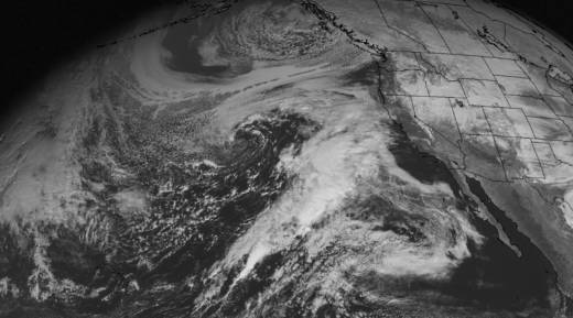
Original post (5 p.m. Friday): When you're a layperson telling the general public about a great weather cataclysm that's forecast to unfold in the next day or two, it's always in your mind whether the thing will really happen. But we're working on the assumption now that the various highfalutin supercomputer-driven weather models and the humans who interpret them will prove correct in their forecast of a rainy, windy weekend for the Bay Area and Northern California.
Forecasters across California say the storm this weekend, fed by a dense plume of moisture drawn from the subtropical Pacific, will be one of the wettest the state has seen in more than a decade. The weekend could see a foot of rain falling in isolated areas of the Santa Cruz Mountains and in parts of the Sierra foothills. Rain falling over high elevations of the Sierra Nevada will release large volumes of runoff and lead to rises in rivers and streams flowing down to the Central Valley.
One example of the impact of that spike in runoff and river levels: A rapid rise forecast on the Merced River has prompted the National Park Service to shut down access to Yosemite Valley over the weekend.
Here's a rundown of what forecasters say we ought to expect over the weekend.
1. Timing: Depending on the weather model you look at, rain is forecast to begin early this evening in western Sonoma and Marin counties and spread over the entire Bay Area by midnight Friday. On and off precipitation is expected to ramp up Saturday evening. (A favorite site for forecast details and timing: National Weather Service Bay Area forecast discussion.)
2. Rainfall: The region is likely to see a pretty good shot of rain in what forecasters are calling the opening act of the weekend storm. For the period ending 4 p.m. Saturday, the California-Nevada River Forecast Center's precipitation forecast estimates totals of more than 1.5 inches in northern Sonoma County and the Santa Cruz Mountains, about an inch in inland Sonoma and Marin counties, and less than half an inch in San Jose and most interior valleys.
As the main plume of subtropical moisture arrives at our part of the coast late Saturday evening, rain rates are expected to increase dramatically, especially along the northern Big Sur Coast, the Santa Cruz Mountains, and the hills north of the Golden Gate up to northern Sonoma County. For the 36 hours from 4 p.m. Saturday through 4 a.m. Monday, the CNRFC precipitation forecast estimates totals of 8.33 inches in the Santa Cruz Mountain community of Ben Lomond and 5.36 inches for Venado in northwestern Sonoma. Urban forecasts for the same period, from north to south, include 3.09 inches for Santa Rosa, 3.71 inches for San Rafael, 2.61 inches for San Francisco, and 2.04 inches for San Jose. (A favorite site for following precipitation totals: The CNRFC Observed Precipitation page.)
3. Winds: The National Weather Service says the weekend storm promises two separate episodes of high winds. The first will occur early Saturday morning to Saturday afternoon, the second during daylight hours on Sunday. Gusts as high as 60 mph are forecast for the North Bay hills and mountains, East Bay hills and Diablo Range, and the Santa Cruz mountains. Gusty winds are also expected in coastal area from northern Sonoma down to Monterey Bay.
4. Mountains: Snow, rain and then snow are forecast throughout the Northern and Central Sierra Nevada. Snow levels are expected to start out low early Saturday, then rise dramatically during the day. The snow level will reach 9,000 feet or so by early Sunday before lowering again to 6,000 feet or below on Monday. (Great site for Lake Tahoe area snow forecasts: Tahoe Daily Snow. And for broader Sierra forecasts, see the National Weather Service Sacramento, Reno and Hanford sites.)
5. Flooding: National Weather Service offices throughout Northern California have issued alerts for possible flooding. The Bay Area forecast office has put out a flash flood watch stretching from Saturday afternoon through Sunday evening for Sonoma, Marin and Napa Counties, the San Francisco Bay shoreline, the Peninsula seacoast, the Santa Clara Valley and Santa Cruz Mountains.
Flood watches have been issued for virtually the entire Central Valley and the full length of the Sierra foothills. The main reason for that: forecasts for up to 15 inches of rain in the northern foothills in the Feather River basin.
6. More flooding: The California-Nevada River Forecast Center says dozens of rivers throughout Northern and Central California will be at or near flood stage. That includes rivers that rise and fall very rapidly, as well as the Central Valley's principal rivers.
The Russian River, one of those fast-to-rise, fast-to-fall streams, is expected to rise above flood stage at Guerneville early Monday and crest on early Tuesday. The Sacramento River will reach monitor or flood stage between Red Bluff and the city of Sacramento and begin overflowing a series of weirs designed to divert floodwaters into low-lying bypasses and ease pressure on levees along the waterway. (We're partial to the California-Nevada River Forecast site for flood information and precipitation data.)
