upper waypoint

Rain's Below Average and Snowpack Is Meager; But Don't Worry -- Things Are Going to Get Worse

Save ArticleSave Article
Failed to save article

Please try again

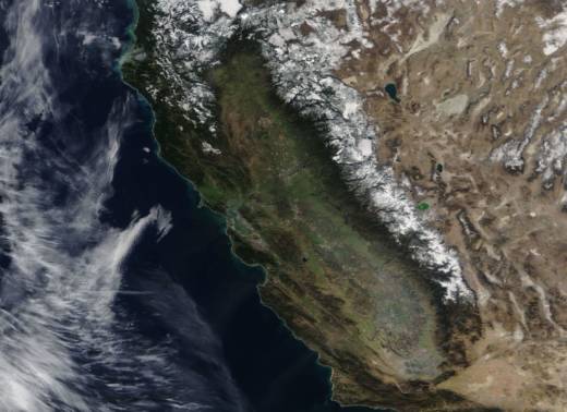
California as depicted in images captured by NASA's Terra satellite on Jan. 28, 2018.  (NASA Worldview)

T

his Thursday, a crew from the California Department of Water Resources will drive up to a meadow above Lake Tahoe to measure how much snow is there.

Media will be on hand to record the ritual, staged once a month between early January and May. The assembled reporters and camera-people will hear DWR's official pronouncement on the State of the Snowpack -- the snowpack and the moisture it contains being a key indicator of what kind of statewide water situation we're looking at in coming months.

We're not going out on a limb when we announce, 72 hours before the official measurement, that the snowpack is disappointingly meager and could well foretell a very challenging water year ahead.

The Department of Water Resources pumps out all kinds of data every day, including statewide snow statistics. And ahead of the coming survey, the daily summary of mountain recording stations from the Trinity Alps down to the south end of the Sierra Nevada shows the statewide snowpack at 30 percent of normal for Jan. 29 and 18 percent of the April 1 average.

There's more: DWR data show the snowpack in all three California regions scraping along near the record-low figures recorded at the deepest point of the five-year drought:
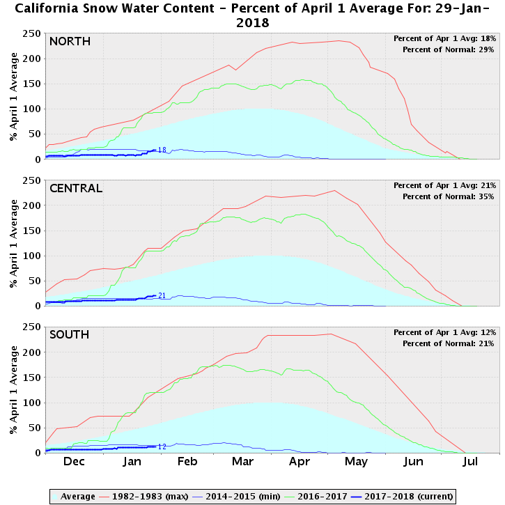
The 2017-18 snowpack, depicted by the heavy blue lines in the graphs above, is close to the record low recorded in 2014-2015. (California Department of Water Resources)

There was a little good news in the stormlets that visited last week. They were cold enough that lower-elevation locations picked up some lasting snow for the first time this season. But if you look at snowfall station by station throughout the mountains, the picture is rather bleak at all elevations.
Sponsored

Don't worry, though: It's going to get worse.

As avid weather watchers know, long-range forecast models have been suggesting for a while that we'd be in for a prolonged period of high pressure -- and dry weather -- after the recent storms moved through. The question is how long the dry spell will last. Here's what forecasters are saying about the answer to that question:

*Atmospheric scientist Daniel Swain, via @Weather_West: "Yet another incredible 16+ day zero precipitation donut hole over California (and the entire American Southwest). Very strong, persistent ridge signal in multi-model ensemble. ... Mid-winter snowmelt likely in #SierraNevada as spring-like temperatures arrive, possibly bringing snowpack to record low level for date."

*National Weather Service/San Francisco Bay Area forecast discussion: "Longer-range models offer little hope of an end to dry conditions across California. The latest GEFS ensemble mean keeps a ridge locked in place along the West Coast all the way through mid- February. The Climate Prediction Center`s 8-14 Day Outlook and 3-4 Week Outlook both indicate warmer and drier than normal conditions persisting across the West."

*NWS Reno forecast discussion: "The forecast pattern now is very stable with dry and warm conditions for at least the middle of February, and likely beyond. Maybe there is hope toward the end of February?"

*NWS Sacramento: "Little to talk about in the extended period as ridging rebuilds over the area. Storm track will be deflected well to the north into the Pacific NW with no real chance of precipitation in Norcal for foreseeable future."

So, in a nutshell: A poor snowfall season to date. Much of the snow that has fallen could vanish as warm, dry weather sets in, even over the mountains. And our next hope for what we used to think of as winter weather appears to be weeks away.

It will not be long until we hear prayers for a March miracle.

lower waypoint
next waypoint