Update 4:39 p.m. Thursday: A nightlong deluge drove several Bay Area rivers toward or past flood stage early Thursday.
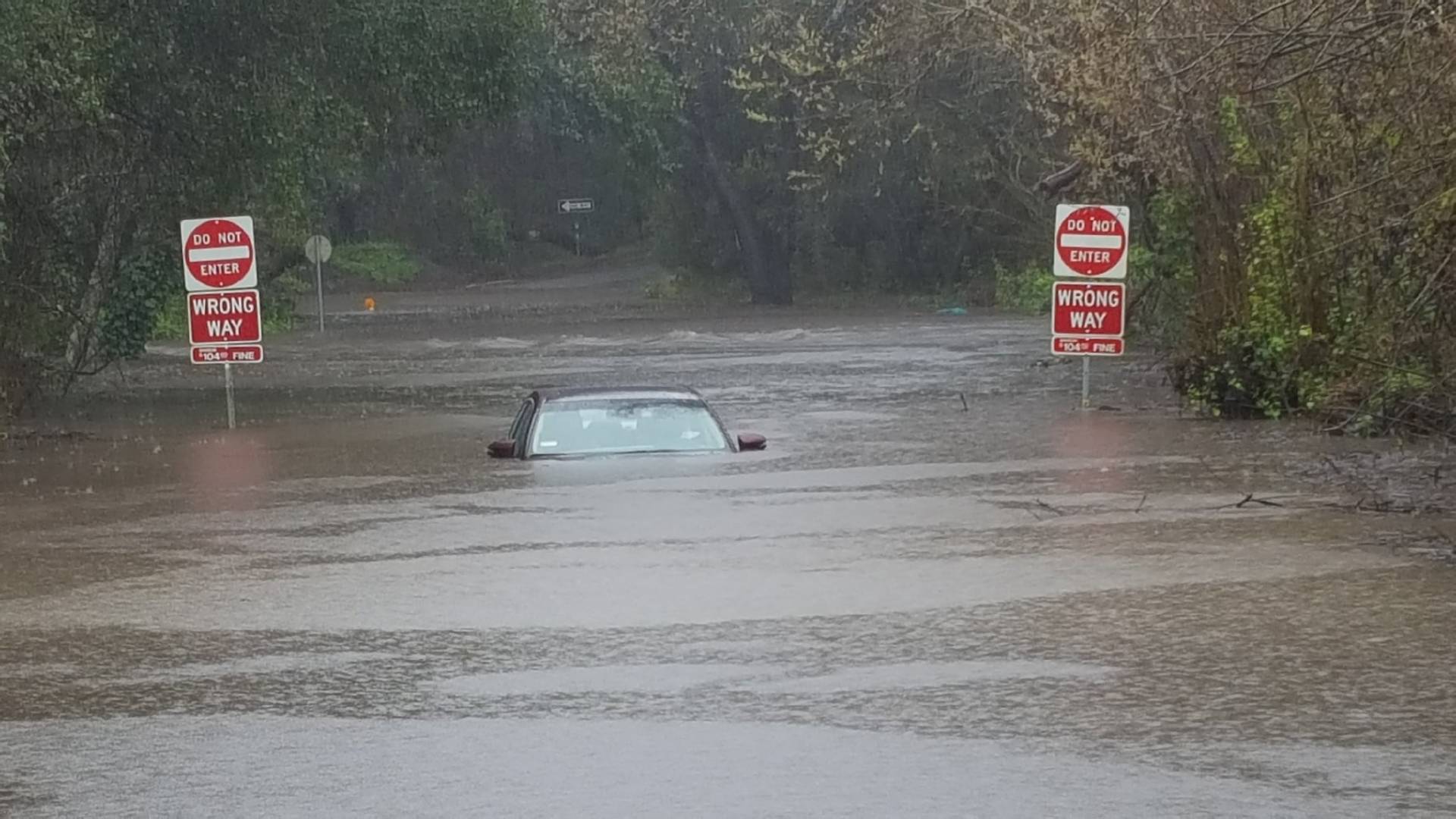
Rapidly rising water on the Guadalupe River triggered a flood warning at 4:21 a.m. and prompted San Jose city officials to issue an alert encouraging residents near the normally placid stream to evacuate.
The evacuation advisory, which applied to a section of the city’s Willow Glen neighborhood, was canceled at 6:30 a.m. as rain slackened and the river receded.
City spokeswoman Rosario Neaves said the city issued the advisory with 2017’s disastrous flooding along Coyote Creek in mind. About 14,000 residents were forced from their homes in 2017, many without receiving warnings that flooding was imminent.
“We committed with Valley Water and the county to not have an incident like (Coyote Creek) to take place again,” Neaves said. “This demonstration is proof of that. … We’ve been taking this incident very seriously.”
In Marin County, California Highway Patrol reported a levee breach near Highway 37 in Novato.
A spokesman for the Marin County Department of Public Works said no homes are threatened, but it will be at least a couple of days before the water recedes enough for officials to begin examining the damage and making repairs. As the evening commute neared, CHP officers and Caltrans engineers were monitoring the rising water along the highway.
Farther north, the Napa and Russian rivers both continued to rise and are now expected to crest at 4 feet above flood stage overnight. As much as a foot of rain has fallen in the Russian River’s watershed since Tuesday night.
David Rabbitt, chairman of the Sonoma County Board of Supervisors, says that’s better than expected. “There will be a little cleanup to do in some parking lots and some properties that are closer to the river, but we should do fine,” he said.
The Guerneville School District announced, however, it would be closed on Friday due to flooding.
The Napa River is expected to top out just above flood stage at both St. Helena and the north side of the city of Napa.
In Sausalito, a duplex slid off its foundation and into another residence on Crescent Avenue, possibly because of a mudslide. One resident inside was rescued and hospitalized for minor injuries.
San Francisco Department of Public Works spokeswoman Rachel Gordon said approximately 65 trees and large limbs had fallen in the city during the storm but caused no injuries. Only a handful of vehicles were damaged.
PG&E reported 17,732 Bay Area customers were still without power as of about 3 p.m. — down from a high of over 31,000 around noon Thursday, as high winds raked much of the region. The regional breakdown at the peak of power outages: North Bay, 9,500; East Bay, 11,241; South Bay, 1,564; Peninsula, 6,409; San Francisco, 3,110.
The weather also continues to cause delays and cancellations at Bay Area airports. A spokesman for San Francisco International Airport said 115 of its 1,250 flights have been canceled so far, mostly routes up and down the West Coast. And 315 flights at SFO have been delayed. Six flights were canceled at Oakland International Airport, due to weather conditions in Las Vegas, San Diego and Seattle.
Totals for the previous 48 hours through 1:15 p.m. Thursday include:
Update 6:55 p.m. Wednesday: More than 8,000 people in the Bay Area were without power Wednesday afternoon following the first wave of a potent atmospheric river storm that has drenched the Bay Area.
Pacific Gas and Electric Co. said 8,053 Bay Area customers were without electricity as of 5 p.m. Wednesday, down from nearly twice that many just a few hours earlier. The vast majority of those still without power — more than 5,000 customers — are in the South Bay, with another 1,665 in the North Bay and just fewer than 1,000 on the Peninsula.
A PG&E spokesman said that, with more stormy weather on the way, trees, tree limbs and other debris may fall on power lines, damaging equipment and interrupting service.
The storm has also brought some impressive rainfall totals and the promise of serious flooding on the Russian River.
As of 3:30 p.m. Wednesday, the National Weather Service reported that downtown San Francisco had already set a new daily record for rain on Feb. 13 with 2.13 inches, with more rain expected later in the afternoon and evening. The previous record was 2.08 inches in 2000.
The California-Nevada River Forecast Center said in an updated forecast early Wednesday that extremely heavy rain in the river’s watershed — for instance, 7.72 inches at Venado, west of Healdsburg, through 6:45 p.m. — will trigger a rapid rise on the Russian River.
The center forecast says the river at Guerneville will reach flood stage — 32 feet — on Thursday morning and crest at 39 feet early Friday.
A flood of that magnitude — about a foot higher than the last storm crest seen on the river, in 2017 — typically inundates homes, businesses and resorts from Guerneville downstream through Monte Rio and closes Highway 116 near Duncans Mills.
The National Weather Service issued a flood warning that for the Russian River at Guerneville starting 4 p.m. on Thursday and lasting until further notice.
Over the course of the day Wednesday, the dense plume of moisture-laden air shifted south from the North Bay and central Bay Area after daybreak, moving over the lower Peninsula, Santa Clara County and the Santa Cruz Mountains.
The region saw on-and-off rain throughout the day, with a second impulse expected to bring another prolonged round of heavy rain Wednesday evening and early Thursday morning.
The National Weather Service on Wednesday issued areal flood warnings for southeastern Marin County until 9 p.m. and southeastern Sonoma County until 10:45 p.m.. It also issued a flood warning for the area around the Napa River starting at 11 a.m. Thursday until further notice. Forecasters expect the river to rise above flood stage around noon on Thursday.
The storm prompted 135 flight cancellations at San Francisco International Airport and 11 at Oakland International Airport on Wednesday, with most of the affected flights involving departures to and arrivals from Southern California and other West Coast locations. An SFO spokesman said about 300 of their 1,250 flights were experiencing average delays of about 80 to 90 minutes through the afternoon.
At least one school district, Two Rock Union in Sonoma County, closed early Wednesday due to flooding, and the Guerneville School District will be closed on Thursday, also due to flooding.
Bay Area transit agencies also reported delays — 10 minutes on some BART lines and up to 20 minutes late on some Caltrain trips. Golden Gate Bridge, Highway and Transportation District said Wednesday night that ferry service in Tiburon on Thursday could be affected due to high winds.
The North Bay, which had the heaviest rainfall by far, experienced the most serious effects.
Scattered road closures were reported across Sonoma County, including roadways in or near Santa Rosa, Rohnert Park, Petaluma, Bodega Bay, Sebastopol, Forestville and Valley Ford.
Several roads in and around Windsor, just north of Santa Rosa, experienced significant flooding. That prompted a road closure at Windsor Road and Skylane Boulevard, and local firefighters helped drivers whose vehicles had stalled in water that came up to the wheel wells.
The National Weather Service Bay Area office also issued a flood warning for some North Bay creeks and a flood advisory for Bay Area locations with poor drainage.
The NWS also issued a coastal flood advisory for parts of the coastline and bay shoreline from 4 to 8 a.m. Thursday, saying southerly winds and excessive rainfall combined with the high tide could result in coastal flooding.
Marin County creeks also showed sharp rises early Wednesday, though all appeared to have crested before reaching flood stage.
And creeks surged elsewhere, too. For instance, this stream north of downtown Oakland:
Regional totals showed a sharp decline in recorded totals from north to south. Totals through 6:45 p.m. Wednesday include:
Original post, updated 10:30 p.m. Tuesday: A double-barreled Pacific storm system arrived in Northern California late Tuesday with heavy rains, high winds and just enough uncertainty about exactly where it will direct its fiercest energy to prompt forecasters to put the entire region on notice for the possibility of widespread flooding and power outages.
The storm system — featuring a river of dense atmospheric water vapor being pulled to the coast by a low-pressure center moving across the ocean from north of Hawaii and a second storm center moving slowly down the coast off California — brought its first heavy rains and gusty winds to the Bay Area before 10 p.m.
Venado, just west of Healdsburg in northern Sonoma County, had recorded nearly three-quarters of an inch of rain by 10 p.m. And a weather station on a ridge about 10 miles east of Cloverdale, near the Sonoma-Lake County line, recorded a wind gust of 72 mph at 9:45 p.m. A 69 mph gust was measured on Mount St. Helena, at the northern end of the Napa Valley.
That’s expected to be just an opening act. The storm is expected to spread a daylong steady rain over the region on Wednesday, broken up by intermittent heavy downpours. For a finale, the weather system is forecast to unload a second wallop of atmospheric river-fed rain early Thursday.
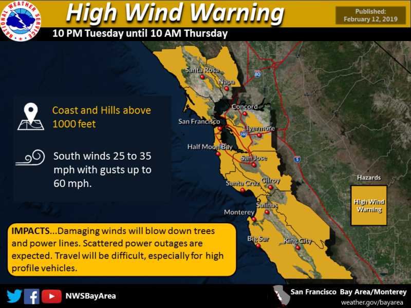
Those forecast conditions, on top of a landscape saturated by recent storms, have led the National Weather Service to issue a flash flood watch for the entire Bay Area from late Tuesday through late Thursday morning. A high-wind warning is in effect for higher terrain — elevations of 1,000 feet and up.
Brian Garcia, the warning coordination meteorologist for the National Weather Service’s Bay Area office in Monterey, said the combination of rain, soaked soil and high winds portends trouble.
“We’re going to put some decent gusts on top of the saturated soil — we’ll probably see a lot of trees down and power outages,” Garcia said.
NOAA’s California-Nevada River Forecast Center’s Coastal forecast rain totals through Friday are ranging from nearly 9 inches in northern Sonoma County to 5 inches in the Santa Cruz Mountains. Much of the North Bay is expected to receive 3 to 5 inches.
Totals at lower elevations are projected to range from 2-plus inches in San Francisco and Oakland to between 1.5 inches and 2 inches along the bay shore and East Bay valleys.
That heavy rainfall is expected to cause a rapid rise on the Russian River, which is forecast to crest about 2 feet above flood stage late Thursday. Flows are expected to spike on the Napa River, too, with the river cresting just below flood stage at St. Helena and downtown Napa.
Most of the rest of California is in for a thrashing, too. Of special concern are conditions in the Sierra Nevada and its western foothills, which have received extremely heavy snowfall in the past two weeks.
The incoming storm is expected to cause snow levels to rise from 2,000 to 3,000 feet Tuesday night to 6,000 to 8,000 feet during the day Wednesday. That means that for some part of the storm, rain will fall on the snowpack. That, in turn, could enhance the runoff down streams and rivers toward reservoirs and valleys below.
Many of the reservoirs are near or at the level at which dam managers may be required to begin releasing water to maintain enough room to accommodate floodwaters and runoff later in the season.
Serious flooding is not forecast — yet — though the river forecast center outlook shows sharp rises on the Sacramento River with water cresting above flood stage at several locations. Water is expected to begin flowing through the Yolo Bypass, the huge flood bypass channel that runs north and west of Sacramento, sometime on Thursday.
Heavy rain is forecast throughout Southern California, too, with amounts ranging from 2 to 5 inches.
A high wind warning has been issued from 10 p.m. Tuesday until 10 a.m. Thursday for the coast and hills above 1,000 feet. (National Weather Service)
Forecasters were still adjusting forecasts as the storm began to brush the coast on Tuesday afternoon.
NWS Bay Area’s Garcia said that’s because weather models have a hard time predicting exactly where the most potent part of an atmospheric river will reach land.
“That kind of granular detail doesn’t really make itself known until all the factors really start to come together,” Garcia said. “And the final detail, the core of the highest amount of precipitable water, is very narrow. That little core — we don’t really know where it’s going to set up — until it really starts raining and pouring in a certain area.”
But atmospheric scientists who have been watching models over the last week are fairly certain about the broad details.
The Center for Western Weather and Water Extremes at UC San Diego’s Scripps Institution of Oceanography, which recently released a new category system for atmospheric river storms, issued a forecast advisory Tuesday afternoon rating the incoming system as Category 4 (out of five categories), a “strong” storm event with high hazard potential.
The center noted, though, that it’s still uncertain how potent the second round of the storm, due Thursday, will be or how long it will last — both key factors in trying to assess the system’s impact in advance.
Sponsored
lower waypoint
Stay in touch. Sign up for our daily newsletter.
To learn more about how we use your information, please read our privacy policy.
Weekend Edition Sunday features interviews with newsmakers, artists, scientists, politicians, musicians, writers, theologians and historians. The program has covered news events from Nelson Mandela's ...