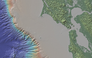
 Topographic image of the Bay Area and continental shelf and slope. The coastline during the peak of the last ice age was at the shelf edge near the Farrallon Islands.
Before reading this post, make sure to check out QUEST’s video segment from last week about sea-level rise in the San Francisco Bay, which provides a nice overview of the problem low-lying areas in the greater Bay Area will face in the coming decades. As good as it is, the QUEST piece is really just an introduction to the problem of current sea-level rise. Sea-level rise is happening and more than 100 million people could be affected globally over the next century even under somewhat conservative projections. This is an tremendously complex problem that will require research across numerous scientific disciplines and creative problem-solving from engineers and urban planners. Like many of the posts I write for QUEST, I’d like to zoom out in terms of the timescales we are used to thinking about and share a little information about geologically recent sea-level changes in the Bay Area.
Over the past few million years, the Earth has flipped back and forth about 20 times between periods of significant continental glaciation, or ice ages, and briefer periods of much less ice. The peak of the most recent ice age was approximately 18,000 years ago. During this time, referred to as the Last Glacial Maximum by Earth scientists, the continental ice sheets that covered much of northern North America and northern Europe reached their largest extent in area. When such vast continental ice sheets grow they “borrow” water from the Earth’s water budget and, as a result, global sea level is lowered. Only 18,000 years ago sea level was 120 meters (400 ft) lower than it is at present.
The map above is a simple sketch map of the paleogeography of the Bay Area at this time*. Think about this for a moment — if you were standing at Land’s End Park on the northwest corner of San Francisco you would not be at the land’s end! The coast would be about 20 miles offshore of the current coast, just beyond the uplands that are now poking out as the Farallon Islands. What is now the Bay was a network of flat valleys with the ancestral Sacramento-San Joaquin River and tributary streams making their way through the narrow notch in the hills at Golden Gate. As temperatures warmed and the continental ice sheets began to melt sea level started to rise. That’s a simplified picture of what the landscape may have looked like at different stands of sea level, but what about the rate at which the sea rose?
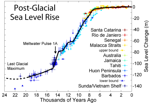
The Pacific Institute, a nonprofit research institute based in Oakland, published a thoroughly researched and very readable report on sea-level rise and its impact on the California coast, which is also featured in the QUEST report. Estimates of future sea-level rise as stated in their report are between 1.0 and 1.4 meters (40-55 inches) by the year 2100. To be conservative (and to simplify a bit) let’s assume this present rate of sea-level rise is 1 meter per 100 years. If we now look at a reconstruction of sea-level changes since the Last Glacial Maximum we see the rise in sea level was not constant — depending on the rate of warming along with other factors the rate of rise varied. As you can see in the graph below the rate of rise slowed significantly about 8,000 years ago. From 18,000 years ago to 8,000 years ago sea-level rose approximately 100 meters (330 ft), which is an average rate of 1 meter per 100 years. In other words, the Earth will soon be experiencing a rate of sea-level rise it hasn’t experienced in several thousand years.


