upper waypoint

February's Storms Doubled California Snowpack, March Could Bring More Wet Weather

Save ArticleSave Article
Failed to save article

Please try again

Skiers on a ski slope.
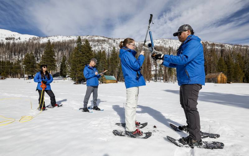
Members of the California Department of Water Resources conduct a snow depth survey at Phillips Station in the Sierra Nevada on Jan. 30, 2024. (Fred Greaves/California Department of Water Resources)

At the start of the year, the California snowpack sat at an abysmal 25% of average, but after a series of storms, the Sierra is glittering white — over the last week, storms added up to 4 feet of snow to the range.

“We were in pretty, pretty bad circumstances earlier this year, and we’ve come a long way,” said Andrew Schwartz, lead scientist with the UC Berkeley Central Sierra Snow Lab. “We’ve kind of clawed our way back into being a decent year.”

Statewide, the snowpack is now 86% of normal for this time of year. And 70% of the April 1 average, which is the end of the water year and the typical height of the state’s frozen reservoir. Storms over the last month more than doubled the size of the snowpack.

At his lab north of Lake Tahoe, over the past week, more than 3 1/2 feet of snow fell during three February storms.

Chasing average

All of these storms — and more potentially on their way in March — put California in a good position to have an average water year. The last time that happened was 2016.

“It’s exceedingly rare that we ever really hit average in California,” he said. “To be around average is kind of nice for once because we’re not worrying about our water resources and our water allocations. But we’re also not worrying so much about [so much] snow that roofs collapse and businesses shut down.”

An average water year can be good for ski resorts like Palisades Tahoe. Big storms can prevent people from accessing resorts, like last winter when 46 atmospheric rivers landed over the West Coast and 32 pummeled Northern California. The storms lifted most of the state from drought conditions, and the sheer volume of water caused catastrophic flooding, bursting levees and reawakening a ghost in the form of Tulare Lake, which had been dry earth in the San Joaquin Valley for over a century.

“There is such a thing as too much snow, where the resort can’t even open sometimes because there is that much snow,” said Patrick Lacey, public relations manager for the resort.

Sponsored

He said this month’s storms piled snow on the mountains around the resort without overwhelming it and nearby communities.

“This has really helped out with our snow totals,” Lacey said. “We are currently sitting at 225 inches for the season. Obviously, that’s not last year’s numbers, but we’re sitting pretty right now, especially in February.”

Lacey said the additional 3 1/2 feet of snow arrived just in time for the Stifel Palisades Tahoe Cup this weekend, where more than a hundred athletes from 28 countries will compete. The ski competition is part of the Audi FIS Ski World Cup circuit.

“It’s skiing really good out there,” he said.

The future is looking average — and snowy

The next potential for rain and snow is early next week, which UC Berkeley’s Schwartz said may help the state to finally climb out of the “deficit we incurred early in the year” with a dry start to the winter.

“It’s still far out to make promises, but it looks like it will be a stormy start to March, which should further help us out,” he said.

Katrina Hand, a National Weather Service Meteorologist in Sacramento, said the agency expects another storm system to move over the Sierra early next week. While the storm may not be as strong as the last several, it could still create travel issues along mountain passes.

“Looking at the current forecast, we do have anywhere from a few inches locally up to a foot in terms of the total snow over that time frame,” she said. “It is still a few days away, so we are fine-tuning those details. But at the very least, I would encourage people to plan for some wintry weather over that late Sunday through Tuesday time frame in the Sierra.”
While the recent snow is great, Michael Anderson, the state’s official climatologist, said the storms did not evenly distribute snow across the Sierra. The Northern Sierra is aglow in white; the Central and Southern Sierra received less snow and may stay that way if storms shift north as spring gets closer.

“It doesn’t mean there won’t still be that opportunity in March for those storms to sag a little bit further south, but we are starting to see that seasonal progression that [typically] moves the storms back north,” he said.

But, Anderson said reservoir levels are in good shape at 118% of the historical average but could benefit from a more extensive snowpack. The California Department of Water Resources reports storms from the start of January to Feb. 20 have provided enough water to supply 4.8 million people or 1.5 million households with water for an entire year.

“Because we had such a big water year last year, it does dent that impact,” he said.

The NWS Climate Prediction Center suggests that moderate to heavy rain and snow could be in the forecast for late February into early March.

“Right now, we’re looking at a fairly strong start to March potentially with these storms, [which could] get us that last bit of water we need to get us to a good spot,” Anderson said.

Anderson said El Niño will likely dissipate in spring, and the possibility of a La Niña year follows. A La Niña year can mean dry conditions, especially in Southern California, but it doesn’t always — as California learned last winter when storm after storm drenched the state.

“We’re going to pay real close attention to that and look and see what the seasonal forecasters can tell us, but right now, we have to be ready for anything,” he said.

Climate change imprints even an average year

For the most part, this year’s storms have not been extreme or even close to the flooding scenarios scientists predict California will experience in a warming world. But Lawrence Berkeley National Lab atmospheric scientist Alan Rhoades said a series of false starts the state experienced over the past few years — where meteorological conditions delayed the rainy season — is due, in part, to the changing climate.

Related Stories

Rhoades notes that the atmospheric rivers hovered over California over the last few years, resulting in lots of rain and snow all at once.

“We’re getting a lot of the rain, but then maybe not always getting the average kind of water year totals you would expect,” he said. “Our future might be more of a whiplash between drys and wets.”

Rhoades said it’s also important to remember that there’s another threat to the snowpack partly caused by anthropogenic climate change. Even if the snowpack grows, just one heat wave could melt a large portion. The state relies on its snowpack to supply a vast agricultural industry and millions of Californians with water.

He recalled a 2021 heat wave in the Pacific Northwest that melted 30% of the Mount Rainier in about a week. Last April, climate scientists warned the public that a heat wave could trigger rapid snowmelt, causing flooding in the Central Valley.

He said there’s strong evidence that human-caused climate change has decreased snowpacks throughout the Western United States for the last 50 to 70 years. He said that is partly due to more snow falling as rain during storms.

“We might have these average years like we’re experiencing in California, but heading into the future, there’s just going to be less opportunity,” he said. “Warming amplifies that natural cycle that we already experience in extremes that we get, and then concentrates storms that we do get into a select number of months in the mid-winter.”

Sponsored

lower waypoint
next waypoint